Hi All, I have been monitoring the Apple Maps service closely over the last few days in particular Transit within the UK.
It looks like Apple are putting a large amount of effort into this side of Apple Maps, not only in key cities or London but across the UK (mostly south at the moment). It looks like we might be in for a surprise with Transit being broader then just 'London' as per the usual Apple way.
These are the changes Ive noticed -
Country wide bus stops are now showing on the Maps:

New Apple Data Provider's Noticed (which has yet to be updated in the source of providers within apple maps):
Mega bus
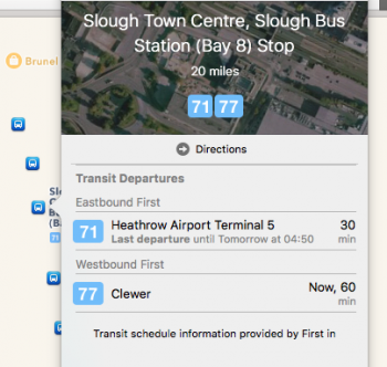
First bus
National express
Rail Air
Albelio in Surrey
Green line
Carousel
Looks like more are actively being added too.
Train Stations in the UK have all started being drawn up with mapped out entrances:

Live Data for buses (specifically) is being displayed outside of London:

Upon Searching for a Station, the Apple search results already automatically know which train providers serve said station (e.g. South West Trains & First Great Western):

These improvements are extremely exciting news in particular for myself (a commuter) and are pointing to the Apple Maps that should have been, what with POI's more accurate then ever now using Trip adviser, Yell, Booking etc. Next stop (excuse the pun), Indoor Mapping, a equivalent of Streetview & HD Satellite imagery (this is very poor in the UK).
Could this be a final ramp up towards the iOS 9 GM release?
It looks like Apple are putting a large amount of effort into this side of Apple Maps, not only in key cities or London but across the UK (mostly south at the moment). It looks like we might be in for a surprise with Transit being broader then just 'London' as per the usual Apple way.
These are the changes Ive noticed -
Country wide bus stops are now showing on the Maps:
New Apple Data Provider's Noticed (which has yet to be updated in the source of providers within apple maps):
Mega bus
First bus
National express
Rail Air
Albelio in Surrey
Green line
Carousel
Looks like more are actively being added too.
Train Stations in the UK have all started being drawn up with mapped out entrances:
Live Data for buses (specifically) is being displayed outside of London:
Upon Searching for a Station, the Apple search results already automatically know which train providers serve said station (e.g. South West Trains & First Great Western):
These improvements are extremely exciting news in particular for myself (a commuter) and are pointing to the Apple Maps that should have been, what with POI's more accurate then ever now using Trip adviser, Yell, Booking etc. Next stop (excuse the pun), Indoor Mapping, a equivalent of Streetview & HD Satellite imagery (this is very poor in the UK).
Could this be a final ramp up towards the iOS 9 GM release?


