I'm not sure if this is a question I can post on this forum; but since it is related to graphics for publication, I would like to ask this question. I am trying to highlight East Coast of USA in the USA map with some color, while keeping the state borders. I tried "live trace" with CS2 Illustrator with a generic map from a web site; but, it is not working out too well. Is there a better way to do this?
Got a tip for us?
Let us know
Become a MacRumors Supporter for $50/year with no ads, ability to filter front page stories, and private forums.
how to trace the map with CS2
- Thread starter YS2003
- Start date
- Sort by reaction score
You are using an out of date browser. It may not display this or other websites correctly.
You should upgrade or use an alternative browser.
You should upgrade or use an alternative browser.
How about a "select color". Say the boarders were black, so you select black and make a new layer with your selection. Then fill it in with a color you want and adjust the opacity of the layer so the details on the map show through. Hope it works.
With this map just use the paint bucket. In my previous post I thought the map was detailed.YS2003 said:There are a bunch of maps available on the web and I found this site I just want to use the simple USA map with individual state borders to hight light certain states with color (while keeping the state borders visible).
Don't I need to create a path so that color will stay in a particular state even if I put a layer on that base map? I am wondering what would be the best way to get the path of the map (both outline and state boarder) so that I can do the live paint for the state for highlight.
YS2003 said:Don't I need to create a path so that color will stay in a particular state even if I put a layer on that base map? I am wondering what would be the best way to get the path of the map (both outline and state boarder) so that I can do the live paint for the state for highlight.
don't bother with a path just make a new layer highlight the area you want, paint tool reduce the opacity then merge the two layers when you're happy wit it.
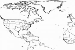
blank USA (and World Map) with Political Borders
I am looking for the clean blnak USA and Word maps with political (or state) borders. I would like to use them to high light certain states (in USA) and countries in the world with color to show where my company's offices/agents are located.
I used the live trace on one of those free maps I found on the web and painted with paint bucket. But, the finished product was not that clean looking and I am wondering if someone can suggest the better to go about completing this task.
YS2003 said:I am looking for the clean blnak USA and Word maps with political (or state) borders. I would like to use them to high light certain states (in USA) and countries in the world with color to show where my company's offices/agents are located.
I used the live trace on one of those free maps I found on the web and painted with paint bucket. But, the finished product was not that clean looking and I am wondering if someone can suggest the better to go about completing this task.
I have access to shapefiles for the world... I can get states, counties, cities and roadways... pretty much anything. I can then save these out as jpegs...
See attached.
If there's something a little more precise you're looking for let me know... I'll see what I can do. If you provide me with details and an email address I can get you pretty much anything.
🙂
Attachments
Bring the map into Photoshop select the "Wand" set tolerance to about 10 and click on the area you want to highlight with color, then set the color you want in the foreground and (once the selection is complete) type "option+delete" to fill the selection with the foreground color. Tweak as necessary and repeat 😎
Register on MacRumors! This sidebar will go away, and you'll see fewer ads.