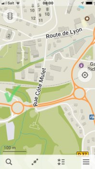
And yes, I reported this to both Apple & TomTom well over six months ago.
No worries, I only question my employees regarding mapping/surveying issues. FWIW, I pretty much always carry a Thomas Guide wherever I go. Also, I was alluding specifically to traffic-related issues and not roadway-layout issues in my OP.
Roadway data is a whole different procedure, and a real change can take up to two-to-three years to go from being built out to actually showing up in a map app/portal. A developer hires my firm, a development is planned and approved, the development "sits" until all structures are approved (sanitary, water, storm, concrete structures, roadway asphalt base lift), the governing agency ultimately approves the development, the final asphalt lift is installed, then the plans are submitted to the agency and the surveyor. Sometime later, those plans head to a GIS department, which digitizes those plans (more likely) or imports/massages a CAD base file or DXF file (less likely) - and the city/county engineer finally stamps the plans and the city/county planner "blesses" the street names and anything else in the long checklist to approve the next step - opening the development to the public.
Then, one day - maybe - just like you decide you want to buy a set of knives or a car, a company like Google or HERE or Tele Atlas or Bing picks up the phone and asks "do you have any mapping updates for your jurisdiction?" There is nothing "automatic" by Google or HERE or Tele Atlas or Bing for incorporation of new/updated data. Honestly, I am only now seeing updates in aerials and roadways from the 2010/2011 data dumps. And, yes, I get the frustration - one of my projects straddled a roadway that was breached by the Corps of Engineers
almost 5 years ago and against the wishes of the county and the Corps didn't report it (they pretty much never give a sh** about anyone besides themselves in the field. I reported the breach while in the field and only GMaps reflects the routing change - I even sent Apple photos of proof, and they don't give a crap either. My Thomas Guide shows the closure…
Apple "leases" it roadway mapping data from so many entities that I'm aware of it's hard to pin down what entity is actually responsible. I pretty much don't waste my time with submitting roadway changes - keep in mind that you're not a licensed surveyor and surveyors always get top billing in this food chain, and they're generally the approving source of roadway layouts in my industry. There's no means I'm aware of to streamline this procedure. Surveyors are cautious beasts. Cheers.


