Become a MacRumors Supporter for $50/year with no ads, ability to filter front page stories, and private forums.

applecomet0007

macrumors newbie
Original poster
Jul 19, 2018
3
0
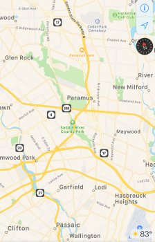
Why does Apple maps roads color change when zooming in and zoom out? Looks like it happens only on some state highways but not Freeways/ Interstate highways.

When normal:
upload_2018-7-19_18-55-17.jpeg

When zoomed in:
upload_2018-7-19_18-55-28.jpeg


And what does yellow and orange colors mean on roads?

I’m on iOS 12 with iPhone 6S
 

Attachments

  • upload_2018-7-19_18-53-52.jpeg
    upload_2018-7-19_18-53-52.jpeg
    1.6 MB · Views: 788
Why does Apple maps roads color change when zooming in and zoom out? Looks like it happens only on some state highways but not Freeways/ Interstate highways.

When normal:
View attachment 771616
When zoomed in:
View attachment 771617

And what does yellow and orange colors mean on roads?

I’m on iOS 12 with iPhone 6S

Orange indicates interstate highways. Yellow indicates state highways and county parkways. White indicates local and private streets.

The color change when zooming in/out helps you differentiate these roads.
 
Orange indicates interstate highways. Yellow indicates state highways and county parkways. White indicates local and private streets.

The color change when zooming in/out helps you differentiate these roads.
Just a slight addendum. Looks like yellow is more about average traffic count. So a higher traffic count gets a road a yellow. Of course all highways would be yellow but there are local roads that are yellow too.

Screen Shot 2018-07-20 at 6.29.20 AM.png
 
  • Like
Reactions: applecomet0007
[doublepost=1532114221][/doublepost]
Just a slight addendum. Looks like yellow is more about average traffic count. So a higher traffic count gets a road a yellow. Of course all highways would be yellow but there are local roads that are yellow too.

View attachment 771689
#4
After examining closely, I think the roads which are directly connected to local streets/residential streets are colored Yellow. All other highways which do not have a direct connection to local streets/residential streets are colored orange.

During zoom in and zoom out the color changed depending on the major portion of the highway I guess. If most of the highway intersects with local streets its Yellow otherwise its Orange.
 
Last edited:
[doublepost=1532114221][/doublepost]
#4
After examining closely, I think the roads which are directly connected to local streets/residential streets are colored yellow. All other highways which do not have a direct connection to local streets/residential streets are colored orange.
Orange are properly called limited access roads witch include Interstates and others types of highways in the US.
https://en.wikipedia.org/wiki/Limited-access_road

Again yellow looks to be traffic count related. In my pic I show LOCAL streets that some are yellow and some are white. Notice that Cumberland Boulevard changed from yellow to white and this is a point that most traffic turns right on Akers Mill. I see plenty of local streets that are yellow and white and the yellow ones are busier. Here is a close up of Cumberland Boulevard changing from yellow to white where the traffic count goes down.

EDIT: Also including another example right below.

Screen Shot 2018-07-20 at 3.30.29 PM.png


Screen Shot 2018-07-20 at 3.37.06 PM.png
 
Orange are properly called limited access roads witch include Interstates and others types of highways in the US.
https://en.wikipedia.org/wiki/Limited-access_road

Agin yellow looks to be traffic count related. In my pic I show LOCAL streets that some are yellow and some are white. Notice that Cumberland Boulevard changed from yellow to white and this is a point that most traffic turns right on Akers Mill. I see plenty of local streets that are yellow and white and the yellow ones are busier. Here is a close up of Cumberland Boulevard changing from yellow to white where the traffic count goes down.

View attachment 771784
True...I noticed that too.. ...
 
The colour coding is the same in Europe:

Orange - major traffic (highways)
Yellow - less traffic (slower speed roads)
White - small roads between buildings, etc.
 
  • Like
Reactions: applecomet0007
Register on MacRumors! This sidebar will go away, and you'll see fewer ads.