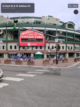
That's another thing! Haha half of my town has 3D satellite view. The western half...doesn't.I’m surprised by the satellite imagery as well. Most of New Jersey isn’t even 3D.
Got a tip for us?
Let us know
Become a MacRumors Supporter for $50/year with no ads, ability to filter front page stories, and private forums.
All Devices Updated Apple Maps
- Thread starter Aussi3
- WikiPost WikiPost
- Start date
- Sort by reaction score
You are using an out of date browser. It may not display this or other websites correctly.
You should upgrade or use an alternative browser.
You should upgrade or use an alternative browser.
- Status
- The first post of this thread is a WikiPost and can be edited by anyone with the appropiate permissions. Your edits will be public.
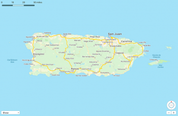
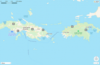
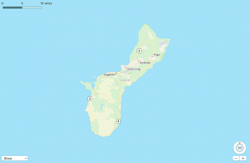
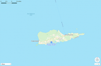
I've got the new maps for the US Territories! Puerto Rico, US Virgin Islands, and Guam all appear to be officially released. I have them on all of my devices.
Missing though (and is mentioned on O'Bierne's post about this expansion) is American Samoa and the Northern Mariana Islands.
Missing though (and is mentioned on O'Bierne's post about this expansion) is American Samoa and the Northern Mariana Islands.
Attachments
Last edited:
I've got the new maps for the US Territories! Puerto Rico, US Virgin Islands, and Guam all appear to be officially released. I have them on all of my devices.
Missing though (and is mentioned on O'Bierne's post about this expansion) is American Samoa and the Northern Mariana Islands.
If anything, it’s great to see that updates are still happening despite COVID-19.
It will be really interesting once the first international update happens!
Yeah it sounds like it went live yesterday. Must've been late since I checked in the evening and didn't see anything. I wasn't sure how working from home would affect this! I'm happy to see this is still able to continue!If anything, it’s great to see that updates are still happening despite COVID-19.
It will be really interesting once the first international update happens!
Also, I browsed around the US and as of now, there are not any new Look Around areas that I noticed. I'll keep an eye out though, because it seems that there are some releases that happen when a new map area is released. (But not necessarily right after. We could still be a ways off from seeing more of those, who knows)! Hope to see the Chicago area soon though!
Nice! I noticed that some newer buildings had appeared in various locations around New York City, and that some existing buildings had better modeling. Still missing my White Castle, though....
Yeah, after reading this I decided to take a look around my area again just so see if I noticed anything else than what I recently mentioned. No new building changes other than the ones I recently mentioned. However...I can almost swear that the colors have been altered slightly so they can better contrast with each other. Specifically the different shades of green they use to show areas that are more tree covered and the green they use for open fields/marsh/farmland. Maybe my eyes are messing with me (and I can't really compare since I didn't keep my screenshots), but I feel like the already darker shade of green...was made a little more "vivid" and the other shade of green was also changed slightly. As for Dark Mode, the greens are still a little tough, but I almost feel like that has been adjusted (VERY slightly).Nice! I noticed that some newer buildings had appeared in various locations around New York City, and that some existing buildings had better modeling. Still missing my White Castle, though....
It just feels like something changed.
[automerge]1587056343[/automerge]
I agree. Really the only thing I notice in my town is that the places that outright closed for the duration...their card in Maps says "temporarily closed". But everything else that's still open, it's showing their normal operating hours despite the fact that NONE of these businesses are operating under those same hours. Some may close at their normal time, but they don't open at their normal time. Some are the opposite of that. Some shortened their hours on both ends. None of which are reflected. What you mentioned would definitely be a huge help because a lot of our businesses that are doing delivery, for instance...did NOT offer that normally. Really the only way people know these businesses are doing this...is if they follow the business on Facebook/Twitter/Instagram. Or if they heard about it through word of mouth. Delivery from these places also probably won't continue to do so once this all settles down, since it's small businesses who are doing it simply because it's their only option right now. So it would be nice to know for now, while that lasts.I wish Apple Maps would get business hour/condition updates like Google Maps has. Knowing what is open, has curbside service, delivery, or is closed is a big help during these times.
You may have to go a few pages back to see my picture about it, but at one point, there was a "temporary hours" section listed on a business's card...and I saw it on every business I tapped on. I haven't seen that section ever since then. The thing about those "temporary hours" though was that they were listed as exactly the same as the businesses normal listed hours.
Last edited:
Unfortunately, some significant highway alterations in the New York City area haven't been updated yet. It's been nearly a year now since Interstate 895 was downgraded to State Route 895, and the expressway became a boulevard with traffic signals. Still hasn't been changed on Apple Maps. And a u-turn lane near my home still hasn't been added.
I've reported both multiple times, many months ago.
I've reported both multiple times, many months ago.
Unfortunately, some significant highway alterations in the New York City area haven't been updated yet. It's been nearly a year now since Interstate 895 was downgraded to State Route 895, and the expressway became a boulevard with traffic signals. Still hasn't been changed on Apple Maps. And a u-turn lane near my home still hasn't been added.
I've reported both multiple times, many months ago.
It is like some things are fixed quickly while others, even stuff you would expect to be a quick fix, are left dangling.
I wonder what the "requirement" per se, is. If I had to put a percentage on it, I would say about 98% of the reports I sent in...WERE addressed and corrected. The remaining 2%...some I heard a response about but didn't see any changes...and some I didn't hear back from at all. I had a good mix of "important/ASAP" and "here's a mistake, but it's not really a HUGE deal" ones. Out of all of them, I was never really to see a pattern between what was addressed and what wasn't, in terms of importance. I think I remember way back on this thread that someone said it may have something to do with how many people report it. The more reports=more likelihood of seeing a change and that it might happen faster. Whereas if you're one of only a few...there's less of a priority. But since you're mentioning highway system...I don't think that would apply. I would think that would be an ASAP regardless of how many reports they get.I submitted some pretty important corrections to the highway system. These are things that need to be fixed ASAP in my opinion, but they were never fixed. I emailed the escalation team and never got a response.
LOOK AROUND HAS BEEN ADDED TO THE CHICAGO AREA!!!
Doesn't extend out to where I live though. Crap 😂 However, the city I work in made the cut!
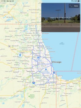
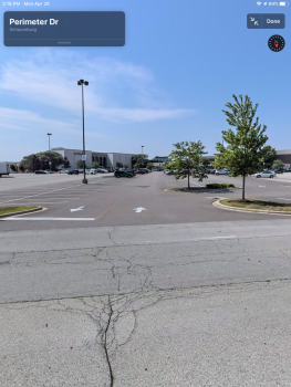
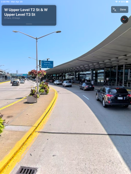
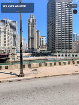
Screenshots below are of the coverage area (Picture #1). Woodfield Mall in Schaumburg (2). O'Hare Airport (3). Apple's Michigan Ave store...across the river in the center of the picture (4). And of course...Wrigley Field (5).
I'd assume everyone is able to view it, but if for some reason it's not showing up for you and you want to see something, let me know! Also...after browsing around the US...it seems that Chicago is the ONLY addition as of now. Coverage is basically everything east of (and including) IL-53 and I-355, and north of (and including) I-80. Northern coverage stops in Zion a little before the state line.
Attachments
Last edited:
Alright, Apple seems to have gone on a 3D model adding spree in my town! I live in an "in-progress" subdivision. Construction has been going on in phases for a few years now. The subdivision has an three open "pods" and one in particular is having a LOT of work being done. There are houses in that pod that have been there for about a year now, but did not have a 3D model in the standard view. As of this morning, they have added models for not only the ones that have been there for a year...but also the NEWER ones. There's models for the homes that were completed less than a month ago. They also added in the tennis courts at our neighborhood park that were not displayed before. (It's still missing a pool though). There's newer construction in our downtown area that also now has 3D models.
It's cool to see them paying this much attention to our town, because even though we're in a metro area...we're on the fringes of it and we tend to get the short end of the stick on other maps, since we're basically the last "bigger" town before you end up in lesser populated farmland. Going west, once you get our of our town, there isn't another big one for about 40 miles. We are basically where the metro area ends. Major props to Apple for keeping up a lot of focus on smaller towns!
It's cool to see them paying this much attention to our town, because even though we're in a metro area...we're on the fringes of it and we tend to get the short end of the stick on other maps, since we're basically the last "bigger" town before you end up in lesser populated farmland. Going west, once you get our of our town, there isn't another big one for about 40 miles. We are basically where the metro area ends. Major props to Apple for keeping up a lot of focus on smaller towns!
Alright, Apple seems to have gone on a 3D model adding spree in my town! I live in an "in-progress" subdivision. Construction has been going on in phases for a few years now. The subdivision has an three open "pods" and one in particular is having a LOT of work being done. There are houses in that pod that have been there for about a year now, but did not have a 3D model in the standard view. As of this morning, they have added models for not only the ones that have been there for a year...but also the NEWER ones. There's models for the homes that were completed less than a month ago. They also added in the tennis courts at our neighborhood park that were not displayed before. (It's still missing a pool though). There's newer construction in our downtown area that also now has 3D models.
It's cool to see them paying this much attention to our town, because even though we're in a metro area...we're on the fringes of it and we tend to get the short end of the stick on other maps, since we're basically the last "bigger" town before you end up in lesser populated farmland. Going west, once you get our of our town, there isn't another big one for about 40 miles. We are basically where the metro area ends. Major props to Apple for keeping up a lot of focus on smaller towns!
This is great news, but is also frustrating as I simply do not analyze Maps enough to notice some of the more subtle changes.
I have to also say, this is why I feel Maps is better than the alternatives. The Look Around post on the main page had a post from someone that I have to give some credit to as they openly admitted (after bashing Maps for never being able to catch up to Google) to not even using Maps for years until curiosity got the better of him and he took a look at Look Around.
Kudos to him for at east admitting it, but just confirms that even on an Apple-centric website like MacRumors, probably most people saying how much Maps suck and Google is way better haven't even used Maps since it was updated years ago.
I committed to using Google Maps for a week straight a few weeks back and confirmed; I hate it still.
As one of those Google Maps users I would say you are ... wrong. That said, everybody is different.
I have been and am still a heavy Google Map (GM) user. As Apple commenced its' major Maps upgrade, and based on the posts of a few here, (you are one of them), I have tried to expand my use of Apple Maps (AM). I always tried AM when updates came out and after OS upgrades. I always went back to GM. I live in an area (Southern California) that enjoyed the early updates. Still, after all this, GM is my goto. I turn in quite a few "corrections" to both Apple and Google.
Biggest recent need in AM that Apple totally missed: updated business information regarding the pandemic.
In GM, businesses in my area have been updated with info like Delivery, Curbside, Takeout, Online Only, Temp Closed, Open, etc... while this is missing in AM. It is a really big help. This could apply to any major event. Had the same issue a couple years back when we had major wildfires. It is the little things, the daily things, that Apple needs to become more enmeshed in.
AM is improving, significantly. It is "prettier". It is still missing basic map/trip functions I have come to rely on.
I am looking forward to continued improvements. I keep testing, checking, and saying "maybe someday". Today, is not yet someday. For me.
My point was not that one is necessarily better than the other. Much of that comes purely down to preference and for Maps people like me, I simply have not experienced those issues or use it in the same way as someone like you might.
The point was that most critics in my experience do not or have not even used the "alternative" app and are basing their judgements solely on either other people's opinions (jumping on the bandwagon) or are basing it on their experience from 5 years ago and haven't even used the app recently.
I agree (and always have) that Google has an edge when it comes to POI info...not always...but the vast majority of the time. Does that mean Apple Maps for me hasn't worked nearly perfectly over the past year? Nope. It has been nearly flawless..or as flawless as my experience with Google Maps (yes...Google is not always perfect).
Does biking directions make Google better? Maybe to some folks, but not for me...have never use them.
Walking directions? I'm sure Google is way better for walking paths and such. Matter to me? Nope...have never used them. I've used walking directions with both in most major cities and haven't found one to be better than the other from a routing perspective.
What I can't stand is the "look" and the way the map totally shifts because Google Maps can't seem to incorporate smooth curve transitions into roads. Absolutely drives me nuts...I'm heading into a slight curve and Google Maps suddenly makes it look as though I'm turning onto a side street.
One thing I can't comment on though is Google Maps on Android. Any major differences? Graphically? Functionally? You have both, correct?
Wish Google would update its look. It is very dated 🤪
On Android, GM is better. More options. More like you see it on a laptop. Even route choices are expanded. You can make it the default for other apps. When planning trips that includes Uber/Taxi/Flights/Rental/Hotel/Shopping linking it all together is doable including international. But that is a big portion AM is missing: Trip Planning. I can plan and link together my vacation in most cases and access it all via Google - Maps is just a piece. The visual piece. In iOS I can do this but at a reduced capacity and cannot make it the default view.
See below for a good example. This was a trip I took a few months back. House to Hotel with multiple stops and POI.

Simple on GM. Easier on Android or laptop. Sort of doable in iOS.
Works great for business trips or even family events like Museum/Food/etc... on one map.
Apple needs to add this type of functionality in future updates.
Updating maps is a big step.
btw - for basic day use - Point A to Point B, I have found AM to be pretty much as good as GM.
Wish Google would update its look. It is very dated 🤪
On Android, GM is better. More options. More like you see it on a laptop. Even route choices are expanded. You can make it the default for other apps. When planning trips that includes Uber/Taxi/Flights/Rental/Hotel/Shopping linking it all together is doable including international. But that is a big portion AM is missing: Trip Planning. I can plan and link together my vacation in most cases and access it all via Google - Maps is just a piece. The visual piece. In iOS I can do this but at a reduced capacity and cannot make it the default view.
See below for a good example. This was a trip I took a few months back. House to Hotel with multiple stops and POI.
View attachment 908589
Simple on GM. Easier on Android or laptop. Sort of doable in iOS.
Works great for business trips or even family events like Museum/Food/etc... on one map.
Apple needs to add this type of functionality in future updates.
Updating maps is a big step.
btw - for basic day use - Point A to Point B, I have found AM to be pretty much as good as GM.
Fair enough...I would definitely like better "in route" options with Apple Maps. It seems to have been better at one point and then actually gotten worse. Like, simply asking to route to a restaurant or other in route stop. Sometimes it is fine and will let me continue on my route after hitting Starbucks or whatever. Other times, it makes me end the navigtion of my initial route...not sure why. I also wish it would default to POI's along my route when I am actually asking for something while driving...doesn't always do that all of the time either.
For me, most of the enhancements would be better implemented if Apple would simply finally offer a web-based version of Maps that will allow routing, entering of corrections, and the ability to plan multiple stop routes and then drop to your phone like Google does. I don't use that feature even when using Google Maps, but I imagine I would use it more if it was available from Apple. And I still believe that Apple could achieve all of this with the wider input from web-based users.
I'm going to be digging into it a bit more in the coming days/weeks. I'm starting a voluntary quarantine today and when it's over, I will be able to go back to my normal department at work. So I've got some time to kill! I'm challenging myself to find all the "little" things. As soon as I first started noticing smaller details, I started getting more curious about how deep Apple actually dug.This is great news, but is also frustrating as I simply do not analyze Maps enough to notice some of the more subtle changes.
I'm going to be digging into it a bit more in the coming days/weeks. I'm starting a voluntary quarantine today and when it's over, I will be able to go back to my normal department at work. So I've got some time to kill! I'm challenging myself to find all the "little" things. As soon as I first started noticing smaller details, I started getting more curious about how deep Apple actually dug.
Please keep us in the loop
Nothing new that I've noticed yet, but I have to give Apple props.
Now that I have all the time in the world (and I'm bored beyond belief already) I've been able to take some time to actually use Look Around for more than just a few minutes at a time. I've spent almost an hour browsing around with it so far this morning. I would have liked to use it to follow my route to/from work, but since the coverage area for Chicago does not extend west of IL-53, I can only use Look Around to view the last 2 miles of my 30-ish mile commute (but hey, that's better than none at all)!
In terms of covered area...Google Street View wins (obviously). But in terms of actual image quality...Look Around takes the cake EASILY! Serious props to Apple when it comes to quality and smooth transition. I even like that "bounce" you get if you tap to move forward but the coverage doesn't go there. It almost gives you an impression that you're hitting a virtual wall. I also really like the effect of depth when you're looking around. (closer objects have a little movement to them when you look around the image).
I'm getting curious about when they will start to expand coverage of areas already released. The coverage of the Bay Area extends almost to my home town. I'd love to see expanded coverage to include it! As well as see the Chicago coverage extend further. We know Apple drove across the entire country, so it's just a matter of when we'll see it. I wonder if it's going to be a case of release all of the major cities first and then expand from there. Or if they're going to start releasing cities AND expanding what's already there. Either way, I'm looking forward to seeing it! The amount of time between releases definitely comes through in terms of quality of it, so the wait is worth it!
Interesting. Browsing around town today, I'm seeing new POI's popping up. (Out of place, however. The good news is I have seen mention of these businesses on Facebook recently. A few of them are brand new and were set to open within the next two weeks, however that is now delayed). I'll be submitting reports for those to correct the locations. As of now, they are close to their actual location. Just have to move the marker a little further down the road!
There was also a color change. There is a farmer's market in town. The market is on the farm itself. Previously, the entire property showed as the very light green color that Apple uses to show fields. The part that the market is on is now shaded in the yellow(ish) color used for other shopping centers. They also expanded the red shading on our hospital campus so now the entire campus is colored red. (The campus has a hospital building, a fitness center, immediate care center, and doctors offices. Previously the only part of the campus colored red was the part that the hospital was on). I also noticed the same change on the campus of the hospital I work at. (It was the same situation. Only the part of the campus that the hospital itself was on was red. Now the entire campus is).
Working from home sure doesn't seem to be slowing the Maps team down, that's for sure!
Register on MacRumors! This sidebar will go away, and you'll see fewer ads.


