Become a MacRumors Supporter for $50/year with no ads, ability to filter front page stories, and private forums.

newtestleper

macrumors 6502a
Jun 17, 2013
566
890
How many times has it happened with the new version? If you get time then please export GPX files for the workouts with invalid data send them to info@workoutdoors.net. Please configure them to include all the fields, including the GPS accuracies (you can configure which fields are included in the Settings tab on the iPhone app). Many thanks!

Just sent five or so that have happened in the last two weeks.
 
  • Like
Reactions: cfc

cfc

macrumors 68040
Original poster
May 27, 2011
3,012
2,515
Got them, thanks for that. I will take a look.

Thanks again for recommending the app despite the issue!
 

tmiles81

macrumors member
Sep 13, 2011
74
34
Melbourne, Australia
This app looks fantastic and i would like to buy it but i have 1 question before i do...

Can i track my runs with your app and then export to rungap to then upload to Strava?

Thanks
 

cfc

macrumors 68040
Original poster
May 27, 2011
3,012
2,515
This app looks fantastic and i would like to buy it but i have 1 question before i do...

Can i track my runs with your app and then export to rungap to then upload to Strava?

Thanks

Yes, the app saves all workouts to Apple's Health Kit, so they can be imported by RunGap and uploaded to any of the many options provided by that app.

Alternatively you can export a GPX of any workout and then upload that directly to whatever system you want.

Thanks for the interest!
 

cfc

macrumors 68040
Original poster
May 27, 2011
3,012
2,515
URGENT: Would anyone who has bought WorkOutDoors please update to the latest version (v2.2) by the end of January.

Previous versions of the app used OpenStreetMap data from a company called Mapzen, who have unfortunately shut down. They announced this two weeks ago but kindly kept their servers running until the end of the month to allow developers time to switch to other services. This is what I have done with v2.2, which now gets the vector data from Mapbox.

The new maps look almost identical to the old ones because the data comes from the same source (OpenStreetMap), and because the maps are rendered by the app itself, so the styles and colours are the same as before. I have made a few minor improvements (e.g. 3D shading around buildings), but most people probably won't notice any difference from the maps in previous versions.

Many thanks to the beta testers who have made it possible to release a new version so quickly. Especially as they had to sacrifice all the new beta functionality that they had got used to. I promise to release another beta soon!

And thanks to everyone at Mapzen for all their hard work. Good luck in the future!
 
  • Like
Reactions: shambolic

chiefs1968

macrumors regular
Feb 27, 2016
187
79
URGENT: Would anyone who has bought WorkOutDoors please update to the latest version (v2.2) by the end of January.

Previous versions of the app used OpenStreetMap data from a company called Mapzen, who have unfortunately shut down. They announced this two weeks ago but kindly kept their servers running until the end of the month to allow developers time to switch to other services. This is what I have done with v2.2, which now gets the vector data from Mapbox.

The new maps look almost identical to the old ones because the data comes from the same source (OpenStreetMap), and because the maps are rendered by the app itself, so the styles and colours are the same as before. I have made a few minor improvements (e.g. 3D shading around buildings), but most people probably won't notice any difference from the maps in previous versions.

Many thanks to the beta testers who have made it possible to release a new version so quickly. Especially as they had to sacrifice all the new beta functionality that they had got used to. I promise to release another beta soon!

And thanks to everyone at Mapzen for all their hard work. Good luck in the future!
[doublepost=1516251101][/doublepost]
URGENT: Would anyone who has bought WorkOutDoors please update to the latest version (v2.2) by the end of January.

Previous versions of the app used OpenStreetMap data from a company called Mapzen, who have unfortunately shut down. They announced this two weeks ago but kindly kept their servers running until the end of the month to allow developers time to switch to other services. This is what I have done with v2.2, which now gets the vector data from Mapbox.

The new maps look almost identical to the old ones because the data comes from the same source (OpenStreetMap), and because the maps are rendered by the app itself, so the styles and colours are the same as before. I have made a few minor improvements (e.g. 3D shading around buildings), but most people probably won't notice any difference from the maps in previous versions.

Many thanks to the beta testers who have made it possible to release a new version so quickly. Especially as they had to sacrifice all the new beta functionality that they had got used to. I promise to release another beta soon!

And thanks to everyone at Mapzen for all their hard work. Good luck in the future!
[doublepost=1516251322][/doublepost]Forgive me if I am off topic but anyway I use to own the Garmin Fenix 3 and there was a feature called track back that will guide you back to your start....does this app have anything similar?
 
  • Like
Reactions: cfc

cfc

macrumors 68040
Original poster
May 27, 2011
3,012
2,515
[doublepost=1516251101][/doublepost]
[doublepost=1516251322][/doublepost]Forgive me if I am off topic but anyway I use to own the Garmin Fenix 3 and there was a feature called track back that will guide you back to your start....does this app have anything similar?

The app has several features to help you track back. The most obvious is the breadcrumbs, which are shown for the whole route (see left screenshot below). It is easy to just turn around and follow the breadcrumbs back.

The second feature is the green "start compass", which always points in the direction of your start, which is shown by a green dot. Tapping the compass shows a textual description of the distance and direction to the start (see the middle screenshot below). This is useful for circular routes where you want to get back to where you started but do not want to track all the way back along your route. You can hide the compass when you do not need it by double tapping it.

The next feature is the map itself. Having a fully interactive map that you can smoothly pan with your finger and zoom in and out with the crown is incredibly handy for any sort of navigation, including tracking back.

Another feature which isn't strictly for tracking back, but which aids navigation, is the ability to display routes from GPX files. These are incredibly easy to follow, especially as the map can auto-rotate according to your direction. If the GPX file has elevation information (which most do) then the route is shown in varying shades of purple: red for steep uphill sections, and blue for steep downhill (see right screenshot). GPX files can also include waypoints to aid navigation and show points of interest.

Hope that helps? Please let me know if you have any more questions. If it's about the app then it's not off-topic!
WatchStripNavigation.png
 

Clonizer

macrumors newbie
Jan 18, 2018
1
1
Thanks for the amazing app.

Will you consider to allow the user to change the map’s label language other than English?
 
  • Like
Reactions: cfc

cfc

macrumors 68040
Original poster
May 27, 2011
3,012
2,515
Thanks for the amazing app.

Will you consider to allow the user to change the map’s label language other than English?

Thanks for the kind words about the app. It's always great to hear that sort of feedback!

The maps are taken from OpenStreetMap, which allows names to be stored in multiple languages. The app first looks for the name in the user's default language, and if that is not present then it uses the default name (which is usually in the local language or in English). However for most items only the default name is stored, so it may not always be translated into the user's language.

One area where the app could be improved is when there is no name associated with a POI, in which case I use the POI type, which is in English. For example if a POI has no name but is of the type "supermarket" then I currently show a supermarket icon and the text "Supermarket". If I were to localise the app for another language then I would translate that text as part of the localisation.

I hope this helps? If the app takes off then I will look into translating it into other languages, as I have done on previous apps, but at the moment I can't afford any translators!
 

solerpaco

macrumors newbie
Dec 21, 2017
4
3
Congratulations by this app. It is very complete.
I want to use this app to run. So for my is very important to see average pace always updated. Is it possible to define the fields to see next to the map?
Thanks in advance
 
Last edited:

cfc

macrumors 68040
Original poster
May 27, 2011
3,012
2,515
I want to use this app to run. So for my is very important to see average pace always updated. Is it possible to define the fields to see?
Thanks in advance

It isn't possible in the current version but the next version will be fully configurable, with more screen formats and the ability to choose which values go where on the screen from a pool over over 60 live values, including average pace (plus current pace, lap pace, previous lap pace etc). This version will also provide interval notifications, limit alerts and much more.

I aim to release this new version in the next month or so depending on how testing goes. It has been in beta testing for a while but I got a bit side-tracked by the sudden need to change map suppliers. However I am now working on the new functionality again and hoping to get a version to testers in the next week that has the new workout functionality and also the new maps.
 

solerpaco

macrumors newbie
Dec 21, 2017
4
3
It isn't possible in the current version but the next version will be fully configurable, with more screen formats and the ability to choose which values go where on the screen from a pool over over 60 live values, including average pace (plus current pace, lap pace, previous lap pace etc). This version will also provide interval notifications, limit alerts and much more.

I aim to release this new version in the next month or so depending on how testing goes. It has been in beta testing for a while but I got a bit side-tracked by the sudden need to change map suppliers. However I am now working on the new functionality again and hoping to get a version to testers in the next week that has the new workout functionality and also the new maps.

Well done!! I wait impatiently for this update. ;)
I you need people to test futures updating I will be happy to help.
Thanks again
 
  • Like
Reactions: cfc

oeagleo

macrumors 6502a
Feb 5, 2016
712
417
West Jordan, Utah
Hello,
I'm coming from a Garmin Fenix 5x, and from all outward appearances, the Work Outdoors app does what the F5 does, import trail, show map, guided hike, etc. However, I believe the AW shows about a 5 hour battery life with the GPS on, but I'm wondering if anyone has tested the battery with Work Outdoors, using the GPS, Maps, and as an activity. Would that be comparable to the 5 hour mark, or would it degrade due to the use of the map?
Thanks in advance.
 

cfc

macrumors 68040
Original poster
May 27, 2011
3,012
2,515
Hello,
I'm coming from a Garmin Fenix 5x, and from all outward appearances, the Work Outdoors app does what the F5 does, import trail, show map, guided hike, etc. However, I believe the AW shows about a 5 hour battery life with the GPS on, but I'm wondering if anyone has tested the battery with Work Outdoors, using the GPS, Maps, and as an activity. Would that be comparable to the 5 hour mark, or would it degrade due to the use of the map?
Thanks in advance.

The map takes up a negligible amount of battery power compared to GPS and HRM, so WorkOutDoors has the same 5 hour battery life as other workout apps. And it will last much longer if you have your iPhone with you to provide the GPS.

It is also possible to switch off the HRM if you use "Workout Power Saving Mode", which can be enabled in the Watch app on the iPhone. However I don't know how much battery that saves, and it also turns off mobile data in LTE models, which may not be what you want (although all maps can be downloaded for use offline).
 

oeagleo

macrumors 6502a
Feb 5, 2016
712
417
West Jordan, Utah
The map takes up a negligible amount of battery power compared to GPS and HRM, so WorkOutDoors has the same 5 hour battery life as other workout apps. And it will last much longer if you have your iPhone with you to provide the GPS.

It is also possible to switch off the HRM if you use "Workout Power Saving Mode", which can be enabled in the Watch app on the iPhone. However I don't know how much battery that saves, and it also turns off mobile data in LTE models, which may not be what you want (although all maps can be downloaded for use offline).

That will probably work, I'll be using a chest strap or OHR on my arm (Either Scosche Rhythm+ or the new Tickr-Fit), so the OHR on the watch won't be used. I think that will work fine for my use. Now, to wait until uncle Jack (Frost) leaves, and I can actually go out and give it a shot.
Thanks for the quick reply
 

cfc

macrumors 68040
Original poster
May 27, 2011
3,012
2,515
That will probably work, I'll be using a chest strap or OHR on my arm (Either Scosche Rhythm+ or the new Tickr-Fit), so the OHR on the watch won't be used. I think that will work fine for my use. Now, to wait until uncle Jack (Frost) leaves, and I can actually go out and give it a shot.
Thanks for the quick reply

Several people use the Scosche with WorkOutDoors and it works well. I haven't heard any feedback about the new Tickr yet.

If you do buy the app then please let me know what you think of it, and especially what could be improved.
 

oeagleo

macrumors 6502a
Feb 5, 2016
712
417
West Jordan, Utah
I took a quick look at it , and bought it immediately. I'm just waiting for winter to get over with so I can play with it! I'm really impressed with what you've done with it, effectively turning my AW into a Fenix 5x, only with a shorter battery life. Once I can get out with it, then I'll add more, but from the armchair, it's impressive.
 

cfc

macrumors 68040
Original poster
May 27, 2011
3,012
2,515
I took a quick look at it , and bought it immediately. I'm just waiting for winter to get over with so I can play with it! I'm really impressed with what you've done with it, effectively turning my AW into a Fenix 5x, only with a shorter battery life. Once I can get out with it, then I'll add more, but from the armchair, it's impressive.

Many thanks for buying the app. Glad you like it and I hope that stays the case when you test it out for real!

In terms of the battery use, one of the app's (much appreciated) beta testers, who does a lot of running, just reported that the app used up 24% over 81 minutes when the iPhone was not present. This translates to about 5.5 hours in total, which is pretty close to Apple's figures.
 

shambolic

macrumors regular
Oct 27, 2003
126
5
Staten Island, NY
In terms of the battery use, one of the app's (much appreciated) beta testers, who does a lot of running, just reported that the app used up 24% over 81 minutes when the iPhone was not present. This translates to about 5.5 hours in total, which is pretty close to Apple's figures.

That would be me, and it's been a real pleasure to be invited to beta test and provide feedback. This was on a Series 3 with cellular enabled, and even without streaming music the cellular radio is definitely a significant contributor to battery usage. I've done some longer runs (20+ miles, 2.5 hours) with WorkOutDoors where I've disabled cellular either before or at some point early in the run, but still playing stored music and using GPS/HR, with cached maps transferred to the watch app from the iPhone app, and that extended the battery life considerably. So the watch can certainly be used for longer activities, which was a pleasant surprise to me.
 
  • Like
Reactions: cfc and oeagleo

oeagleo

macrumors 6502a
Feb 5, 2016
712
417
West Jordan, Utah
Quick question for anyone who may know, if I'm using the app, (or even the native outdoor walk app, for that matter), if I have my phone with me, does the app use the GPS on the watch, or on the phone? Is there anyway other than leaving the phone in the car to force the watch to use it's GPS, rather than the phone?
I'm trying to figure out which GPS is more accurate, the phone, or the watch, and I can't tell what the app (WorkOutdoors) is using.
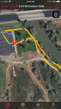
Also, can anyone explain the "Gray" areas of my track in this photo? This is the first time I've played with the app, and while I really do like it, I don't think I understand everything about the app.

Screenshot.jpg
 

Attachments

  • Screenshot.jpg
    Screenshot.jpg
    361.5 KB · Views: 222
Last edited:
  • Like
Reactions: cfc

cfc

macrumors 68040
Original poster
May 27, 2011
3,012
2,515
I am glad to hear that you really like the app. To be honest I am not 100% sure what the grey dots on Apple's app signify but my best bet is if you stop or go quite slowly (maybe looking at the app) then the Activity app shows a gap with grey dots at the beginning and end of the slow period. I have actually made changes in the current beta version which seem to fix this (by sending all points to Apple instead of only every 5m).

The app uses the iPhone GPS if the iPhone is present and the Watch GPS if it isn't. I don't think that there is any way for an app to specify that it wants use the Watch GPS, but please correct me if I am wrong (and I will change the app accordingly).

Generally I find that the iPhone GPS is more accurate than the Watch GPS, but you can test this by using WorkOutDoors. It keeps track of the GPS accuracy throughout the workout, and you can then analyse this in WorkOutDoors iPhone app. If you select a workout and then select the "GPS" graphing option then it shows a profile of the GPS accuracy throughout the workout and also colours the trail on the map accordingly (blue for good, grey for poor).

If you swipe your finger across the profile then you can see the GPS position arrow move on the map and the figures at the top (including GPS accuracy) change to show the values at that point. This way you can find the GPS accuracy in metres for any point on the workout, and also get an overall feel of the accuracy from the colour and profile.

When I have done this for the same route with and without the iPhone I tend to find that the accuracy is better with the iPhone, but it is worth testing for yourself.

Note that you can also export the accuracy data in the GPX file. It is not included by default (because it is not a standard GPX value) but if you go to the Help & Info tab and enable "GPX Accuracies" then you will see all the accuracy values in the file.

TLDR: WorkOutDoors provides a lot of ways to analyse the GPS accuracy but it doesn't allow you to force the watch to use its own GPS, because I do not think that is possible (but would be happy to be corrected).
 

oeagleo

macrumors 6502a
Feb 5, 2016
712
417
West Jordan, Utah
I am glad to hear that you really like the app. To be honest I am not 100% sure what the grey dots on Apple's app signify but my best bet is if you stop or go quite slowly (maybe looking at the app) then the Activity app shows a gap with grey dots at the beginning and end of the slow period. I have actually made changes in the current beta version which seem to fix this (by sending all points to Apple instead of only every 5m).
.

Thinking back, I think you may be correct in your assumption, as I was fiddling with the app, and since I was using the Scosche Rhythm+ HRM, and it has taken a tendency to cut out every once in a while, I think that is what I was doing, rather than a straight, solid walk. The GPS track is a nice solid blue, indicating that it's a good fix, so I believe that's correct. After all, it was finally warm enough (41F) that I felt I could at least try the app out. From what I see, (FWIW) the app is fantastic, I really like it, best couple bucks I ever spent!
Thanks for the help, I still don't understand all I know about the app, but I'm learning! :)
 
  • Like
Reactions: cfc

cfc

macrumors 68040
Original poster
May 27, 2011
3,012
2,515
Thanks. I figured that the dots were because the Activity app is quite sensitive to slow movement, so it's good to hear that is probably the case.

If you have any more questions then feel free to ask. I want as much feedback as possible so that I can improve the app as much as possible.

Glad to hear that you like the app that much. Maybe I should raise the price! :)
 
Register on MacRumors! This sidebar will go away, and you'll see fewer ads.