Become a MacRumors Supporter for $50/year with no ads, ability to filter front page stories, and private forums.
Hi. I just downloaded the app to try. Immediately saw 'Sailing' as an activity. Any chance in the future that maybe nautical miles could be a measurement? I try to pretend to be a sailor. My crew looks at me weird when I speak sailing terms. "Just say right and left dummy!".

No hurry. Boat is put away for the winter. LOL.

Look forward to trying out the app.
 
Many thanks for buying the app. I didn't even think of nautical miles, but I will add it in the next version, due out next month. Speeds will be shown in knots.

Do you think I should make it an option in addition to miles, or (much easier) just show nautical miles and knots instead of standard miles when the user is sailing?
 
I would personally just use nautical miles/knots only but others may still like standard miles as an option also.

Thanks!
 
Thanks! I will offer users both then, as well as kilometres.

If you try the app for any other activities then please let me know what you think and if there are any other changes that you would like to see.
 
Is it possible to have the name of the street you’re currently on be one of the things displayed at the bottom of the map?
 
It is possible but would be a bit fiddly. At the moment the app does not keep a correlation between the current location and the roads. It simply draws the GPS icon/trail breadcrumbs at wherever the location is/was.

I will look into it, but it probably won't be in the new version next month. I will bear it in mind in the future though.

At the moment you can tap any road name (or POI) and it will enlarge the name on the map and also show it at the bottom of the screen, but this doesn't currently work for roads without a label. I have been considering making this work even for unlabelled roads, so I may add your "current road name" feature at the same time. Both features would require code to determine the name of the nearest road to a given location, so it makes sense to do them together.

Thanks for the suggestion!
 
  • Like
Reactions: newtestleper
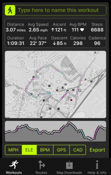
First walk. Very impressed. It was paused at one point when I looked at it and had to resume it manually, but it doesn’t appear to have missed any part of the walk. Is it supposed to auto-resume after a pause?

As for the stats, I particularly like the elevation data. The loop I tend to do circumnavigates a river, and this is evident with the climbs and falls.
 

Attachments

  • 9E18F66D-B92C-4F64-97D2-D4CEE2099A5D.jpeg
    9E18F66D-B92C-4F64-97D2-D4CEE2099A5D.jpeg
    370.2 KB · Views: 205
  • Like
Reactions: cfc
Glad you like it. The pause may have been because you accidentally pressed both side buttons at once. This is something that Apple added in watchOS 4 but you can disable it in the app’s settings (force press the screen).

It’s good to hear that you find that the stats are useful. If you touch the profile below the map and move your finger from side to side then you can see the stats at any given point during the workout.

Many thanks for the feedback.

Ah. Not accidental actually; I took a screenshot to demonstrate the app to someone.
 
  • Like
Reactions: cfc
Ah yes - I keep the 2 button pause turned off for exactly that reason!

It’s a bit odd that Apple use the same button combination for two very different operations, but I guess there aren’t too many possible options on the Watch.
 
Ah yes - I keep the 2 button pause turned off for exactly that reason!

It’s a bit odd that Apple use the same button combination for two very different operations, but I guess there aren’t too many possible options on the Watch.

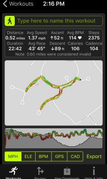
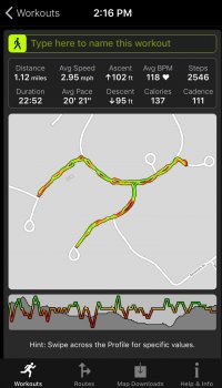
I just finished a walk and was over 0.8 miles at one point but finished with just over 0.5. There’s no chance the app subtracts distance if you retrace over the breadcrumbs is there?
 
Definitely not! I have seen something similar before but very rarely. When you look at the workout on the iPhone do you see a note about some of the route being considered invalid by Health Kit?

WorkOutDoors determines distance from Apple's Health Kit, but uses the simple GPS distance between points as a fallback if HealthKit fails to register any distance, which is what may have happened at the beginning of your workout.
Yes, it’s there. Here’s mine versus my wife’s. Gutted!
 

Attachments

  • FD7CC6CF-30CC-4A71-8921-648AB6F422BF.jpeg
    FD7CC6CF-30CC-4A71-8921-648AB6F422BF.jpeg
    169.7 KB · Views: 199
  • 4710160E-B0BA-4861-A48B-DC0AC347840E.jpeg
    4710160E-B0BA-4861-A48B-DC0AC347840E.jpeg
    165.5 KB · Views: 182
  • Like
Reactions: cfc
Not if you keep making good suggestions from out there!
 
I was triggered by the sailing/NM inputs. if you add flying, your app can be used as a flight/pilot log as well.
 
  • Like
Reactions: cfc
I was triggered by the sailing/NM inputs. if you add flying, your app can be used as a flight/pilot log as well.

That is an excellent thought. I didn't even consider it because Apple understandably don't offer a "flying" workout type, but I guess the "Map-Only" mode would still be great to aid navigation. This mode simply shows the live map, without starting a workout, but with the usual breadcrumb trail and optional auto-rotation.

Unfortunately I know nothing about flying. Would it be useful for pilots to have a live map on their watch, or do most of them have their smartphones mounted on the dash?
 
Hi Ian! Per our email conversation could you tell us a little about the map view or stats view screens options and all the configurable stats you are planning for us runners who don’t necessarily need a map while running, but want distance, pace, average pace, splits, elevation, cadence, heart rate (external or AW), timer, grade, moon phase, time zone, and super bowl prediction?.....;-)

Of course I’m talking about the Watch face for Watch only runners. Thanks!!
 
  • Like
Reactions: cfc
That is an excellent thought. I didn't even consider it because Apple understandably don't offer a "flying" workout type, but I guess the "Map-Only" mode would still be great to aid navigation. This mode simply shows the live map, without starting a workout, but with the usual breadcrumb trail and optional auto-rotation.

Unfortunately I know nothing about flying. Would it be useful for pilots to have a live map on their watch, or do most of them have their smartphones mounted on the dash?
Most Will use an ipad or equivalent with aviation specific software (for example airnav pro or jeppesen). It would however be convenient to use it as a pilots log: time of departure and arrival and route flown, as well as a positioning reference aid when flying “vfr” (visual).
 
  • Like
Reactions: cfc
Most Will use an ipad or equivalent with aviation specific software (for example airnav pro or jeppesen). It would however be convenient to use it as a pilots log: time of departure and arrival and route flown, as well as a positioning reference aid when flying “vfr” (visual).

It sounds like it may be worth adding a "Pilot's Mode" in the future.
 
It sounds like it may be worth adding a "Pilot's Mode" in the future.
I just wanted to chime in and say I downloaded the app and it looks great. As an active pilot, it think it would be a great to get a "pilot mode." Someone mentioned this now being a Fenix...would be great to also be a Garmin G2 as well. Happy to help with any pilot stuff you may need if you need an assist!
 
  • Like
Reactions: cfc
Hi Ian! Per our email conversation could you tell us a little about the map view or stats view screens options and all the configurable stats you are planning for us runners who don’t necessarily need a map while running, but want distance, pace, average pace, splits, elevation, cadence, heart rate (external or AW), timer, grade, moon phase, time zone, and super bowl prediction?.....;-)

Of course I’m talking about the Watch face for Watch only runners. Thanks!!

I can't help with super bowl predictions, but I have gone a little overboard with the customisations in the next version. The current version allows 3 different text sizes, but the next version also allows 3 different screen structures:

1) data at the bottom (as before);
2) data below and alongside the map (in an 'L' shape);
3) a full screen of data.

This gives 9 different possible modes, giving trade-offs between the size of the map, the size of the text, and the number of fields. In all modes you can quickly double-tap to switch to and from a full-screen map. Here are some sample screenshots of each:
WatchStripBottomData.png
WatchStripSideData.png
WatchStripFullData.png

In each case, the user can configure exactly which fields are shown where from an ever-growing palette of live values (currently between 20 and 30). They can also define which values are shown when double-tapping a field (or triple-tapping for the full data screen, because double-tapping shows the map).

In the example below, the top left field in the 'L' shows distance, but will change to show steps when double-tapped. Double tap again to see the speed, and again to get back to the distance. It sounds complicated but it is actually pretty easy to configure exactly what you want.
WatchStripCustomise.png


Hopefully this should provide enough customisation to cater for most people, but if not then please let me know.

This is the most major of many changes in the next version, which I am aiming to release before Xmas.
[doublepost=1511366663][/doublepost]
I just wanted to chime in and say I downloaded the app and it looks great. As an active pilot, it think it would be a great to get a "pilot mode." Someone mentioned this now being a Fenix...would be great to also be a Garmin G2 as well. Happy to help with any pilot stuff you may need if you need an assist!

Many thanks for the offer of help. It probably won't be until the new year because I am mainly focussed on the workout functionality. However if it isn't too much work to make it genuinely useful for pilots then I will add it.

For example someone suggested adding Geocaching functionality and it turned out that WorkOutDoors does most of what Geocachers need already (because they use a tailored version of GPX files) so I am planning to add that soon. If the pilot functionality is similarly simple to add then it would be great to make the app appeal to yet another group of users.
 
  • Like
Reactions: CobraPA and tkukoc
I can't help with super bowl predictions, but I have gone a little overboard with the customisations in the next version. The current version allows 3 different text sizes, but the next version also allows 3 different screen structures:

1) data at the bottom (as before);
2) data below and alongside the map (in an 'L' shape);
3) a full screen of data.

This gives 9 different possible modes, giving trade-offs between the size of the map, the size of the text, and the number of fields. In all modes you can quickly double-tap to switch to and from a full-screen map. Here are some sample screenshots of each:
View attachment 737606 View attachment 737605 View attachment 737607
In each case, the user can configure exactly which fields are shown where from an ever-growing palette of live values (currently between 20 and 30). They can also define which values are shown when double-tapping a field (or triple-tapping for the full data screen, because double-tapping shows the map).

In the example below, the top left field in the 'L' shows distance, but will change to show steps when double-tapped. Double tap again to see the speed, and again to get back to the distance. It sounds complicated but it is actually pretty easy to configure exactly what you want.
View attachment 737604

Hopefully this should provide enough customisation to cater for most people, but if not then please let me know.

This is the most major of many changes in the next version, which I am aiming to release before Xmas.
[doublepost=1511366663][/doublepost]

Many thanks for the offer of help. It probably won't be until the new year because I am mainly focussed on the workout functionality. However if it isn't too much work to make it genuinely useful for pilots then I will add it.

For example someone suggested adding Geocaching functionality and it turned out that WorkOutDoors does most of what Geocachers need already (because they use a tailored version of GPX files) so I am planning to add that soon. If the pilot functionality is similarly simple to add then it would be great to make the app appeal to yet another group of users.

Holy crap I like that bottom right presentation! Because there are so many fields it would be nice if you can eventually add the ability to highlight with a color or red outline certain fields. Apple workout app lets you scroll to highlight one field. I currently do this for pace if trying to improve or HR if running to HR. I can see cadence highlighted for me too since I am working to improve mine. Awesome work Ian! Ready to beta test on the Watch when you are. I like to run with just my AW3 LTE, Scosche and Plantronics ear buds. Which reminds me. If you can add feature to automatically start a playlist like Apple workouts does that would be great!

Really looking forward to this version!
 
  • Like
Reactions: cfc
Register on MacRumors! This sidebar will go away, and you'll see fewer ads.