Become a MacRumors Supporter for $50/year with no ads, ability to filter front page stories, and private forums.
Status
The first post of this thread is a WikiPost and can be edited by anyone with the appropiate permissions. Your edits will be public.
Chiming in here- apologies if it’s been addressed but I didn’t see it. Has anyone gotten the EV routing to work?

Ive looked everywhere and can’t find it. I even spoke with a chat rep who sent me a guide to set it up, but the option to set it up in Maps just doesn’t exist even on 14.1.

Rep said they’ll “notify technicians” but I have a feeling the feature is just straight up missing from 14.

As far as I know, it is t released yet. It will start with BMW and Ford initially with other brands to follow.
 
I do wonder how long this one'll take. When I was reading Justin's post about Canada, he pointed out that while the land area is HUGE...the "stuff" in that land area is less. I could actually imagine this one going somewhat quickly.

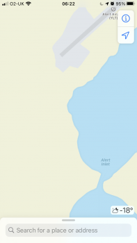
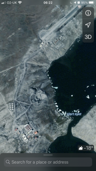
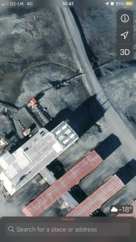
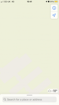
Definitely true although clearly the ‘automated system’ Apple uses hasn’t worked that well in the far north. For example the only bit of Alert that’s mapped is the Air Strip and the buildings (but these are only visible when you zoom right in so this needs fixing). The tracks/roads are all missing. It makes me wonder what else might be missing?
 

Attachments

  • 276B089D-8A51-493E-9E06-00E69CB807FE.png
    276B089D-8A51-493E-9E06-00E69CB807FE.png
    365.7 KB · Views: 220
  • 11E0FF03-3911-439D-B40F-752BD6938BCC.png
    11E0FF03-3911-439D-B40F-752BD6938BCC.png
    3.7 MB · Views: 257
  • Like
Reactions: iOS Geek
And they don’t show up at a different zoom level? Are they “tracks” or actual roads/trails?

I doubt they are numbered/named but they’re fairly large pieces of engineering so I’d expect to see them. Elsewhere unmade tracks are mapped. You have to zoom right (much closer than normal) to even see the buildings.
 

Attachments

  • F21A51B5-E685-440F-995E-0704507C6FD4.png
    F21A51B5-E685-440F-995E-0704507C6FD4.png
    3.9 MB · Views: 242
  • 81F902AD-B80A-449E-B528-64A297BED76A.png
    81F902AD-B80A-449E-B528-64A297BED76A.png
    320.3 KB · Views: 255
I doubt they are numbered/named but they’re fairly large pieces of engineering so I’d expect to see them. Elsewhere unmade tracks are mapped. You have to zoom right (much closer than normal) to even see the buildings.

Hmmm...Agree...seems like something that should have at least been caught by satellite data. Even in the USA, some longer private driveways or parking areas that were most certainly NOT covered by a driving Apple Maps Car are mapped.

You can always drop a pin and suggest an update, but I usually like to wait until full release. As you can see from many examples even in this newer thread, errors or missing data on pre-released Maps is sometimes magicaly fixed/updated when the full release is issued. Not always, but that is why they do a pre-release.
 
Hmmm...Agree...seems like something that should have at least been caught by satellite data. . Even in the USA, some longer private driveways or parking areas that were most certainly NOT covered by a driving Apple Maps Car are mapped.

You can always drop a pin and suggest an update, but I usually like to wait until full release. As you can see from many examples even in this newer thread, errors or missing data on pre-released Maps is sometimes magicaly fixed/updated when the full release is issued. Not always, but that is why they do a pre-release.

Yeah in the U.K. where I am some of the islands (eg Lundy/St Kilda) which aren’t accessible by car from the mainland have the roads/tracks marked so must have been done by another method. For somewhere as well known as Alert I’d expect to have seen this done, even if they have to do it manually!
 
Hmmm...my “home” navigation prompt always works for me.

I actually freaked out yesterday when I got I. The car and it suggested a route to Costco when I opened maps on CarPlay...yes, I actually was going to Costco.

Then, when leaving Costco, instead of suggesting a route home, it suggested a route to my local grocery store instead.

Damn you Apple...yes, I typically go to my local grocery store after Costco to get other stuff from there.

It knows me too well at this point.
Mine gets weird sometimes and suggests random addresses. Like a while back all it showed was Near E Broad St. Not even a number. Then yesterday it picked an address close to home but the # was off a bit.
 
Any thoughts on how Apple will go about releasing their own map data in new countries/regions after they are done with Canada (the last country out of the three they announced during WWDC 2020)? Do you think they will wait until WWDC 2021 and name a couple of countries/regions and then have rollouts throughout the rest of 2021? Maybe they just surprise us with a new country/region early next year (like they did with the areas of the United States) or give us a press release after they publicly release Canda with a roadmap of countries/regions that they plan to expand to in 2021.
 
Any thoughts on how Apple will go about releasing their own map data in new countries/regions after they are done with Canada (the last country out of the three they announced during WWDC 2020)? Do you think they will wait until WWDC 2021 and name a couple of countries/regions and then have rollouts throughout the rest of 2021? Maybe they just surprise us with a new country/region early next year (like they did with the areas of the United States) or give us a press release after they publicly release Canda with a roadmap of countries/regions that they plan to expand to next year.
Nothing official from Apple in that regard, but Justin O’Bierne put a write-up about his thoughts on the possible “nexts”. I’d suggest going to his site and reading that as he dove deep into it, including what we could expect based on when data collection occurred/completed. I believe he titled that post as expansion 11. Theres a pretty decent list of what could be next!
 
Any thoughts on how Apple will go about releasing their own map data in new countries/regions after they are done with Canada (the last country out of the three they announced during WWDC 2020)? Do you think they will wait until WWDC 2021 and name a couple of countries/regions and then have rollouts throughout the rest of 2021? Maybe they just surprise us with a new country/region early next year (like they did with the areas of the United States) or give us a press release after they publicly release Canda with a roadmap of countries/regions that they plan to expand to in 2021.

No one really knows, but my guess is that we will see parts of Europe and/or Australia before WWDC.

No real reason to wait.
 
Any reason why Map app is able to show a walking route to a nearby Train station, but searching for the route from the location to other train station, Map would suggest to walk to bus stop to take bus to the next train station and take train to the destination station?

It seems like the nearby station was not considered when Map calculating the routes to other train stations.
 

Attachments

  • 38A81098-FB49-4252-AC4F-B0A22D1D105F.jpeg
    38A81098-FB49-4252-AC4F-B0A22D1D105F.jpeg
    100.8 KB · Views: 273
Last edited:
I think it might be because China has strengthened their grip on Hong Kong and either explicitly doesn‘t allow mapping by third parties to take place anymore, or Apple doesn’t want to try its luck.

the data collection schedule should have been posted earlier than year 2020.

anyone knows if the schedule had been missing hk at the first place?
 
Nothing official from Apple in that regard, but Justin O’Bierne put a write-up about his thoughts on the possible “nexts”. I’d suggest going to his site and reading that as he dove deep into it, including what we could expect based on when data collection occurred/completed. I believe he titled that post as expansion 11. Theres a pretty decent list of what could be next!

it seems that Apple s data collection schedule posted in the website included only these three countries hence we should expect an update on this schedule before the 2021 convention?
 
Wish we could have voice feedback for alerts only and not for every turn. Currently have to turn all voice off entirely.
 
Found some old screen shots on my phone.

iOS 12 vs iOS 14:

View attachment 968463
View attachment 968462
Since using the new updated maps I've found the navigation screen more cluttered, and the display feels less intuitive and less easy to follow. What I mean is that the apps seems to default to the 'birds eye view' more often now, effectively showing the route ahead in 2D, whereas in the previous version it seemed to remain in 3D mode (i.e. a view where you could see the horizon, as in the screen shots above) which I find a lot easier to follow, a bit more like the original TomTom style. I don't know whether this is really the case, as I can't find any way to prove that this is happening more frequently, but it's definitely felt noticeable.

I've always been a fan of Apple maps of Google maps for navigation as I found Google's interface too detailed and cluttered, but this latest iteration of Apple maps is making me consider another navigation app. I wish there was some way of setting 'view preferences'.

I'm based in the UK and am still trying to figure out if it's just me experiencing these issues?

You can switch to the "birds eye view" anytime you want, by touching the '2D' or '3D' button on the upper right. Although on your CarPlay in the UK, it might be on the upper left.

When navigating, everything is shown in birds eye view by default when driving, with the only exception being when it switches to a top-down view approaching turns.
Thanks. It's the in-navigation where I don't like the top-down view. I feel like the way it displays the maps has changed in the latest iteration, and now shows the top-down view more often than not. It also feels a lot more visually cluttered and less refined, like the early navigation apps. I find a 3D view of about 45 degrees the most useful to navigate by, so it's like I'm looking at the road ahead, rather than having to translate a 2D map into the real world I'm driving through (I know.. I know.. how on earth would I have survived back in the days of actual 2D maps!)
 
Thanks. It's the in-navigation where I don't like the top-down view. I feel like the way it displays the maps has changed in the latest iteration, and now shows the top-down view more often than not. It also feels a lot more visually cluttered and less refined, like the early navigation apps. I find a 3D view of about 45 degrees the most useful to navigate by, so it's like I'm looking at the road ahead, rather than having to translate a 2D map into the real world I'm driving through (I know.. I know.. how on earth would I have survived back in the days of actual 2D maps!)

Apple Maps has always had more of a “higher” view compared to others as well as the “show more of the road” versus the “arrow always facing up” view.

I used to like the more “horizon” view as well...actually, the first release of Maps kind of had this...but I much prefer the way they do it now. I think they’ve done a good job with the auto zoom based on speed/next turn. I’m sure they did a ton of studies to show just enough and at the correct angle to make Maps as easy to understand as possible.

I almost wish I was still traveling as I’m absolutely blown away at how Maps is performing for me locally both from a POI standpoint and with directions.
 
  • Like
Reactions: Watom
Definitely true although clearly the ‘automated system’ Apple uses hasn’t worked that well in the far north. For example the only bit of Alert that’s mapped is the Air Strip and the buildings (but these are only visible when you zoom right in so this needs fixing). The tracks/roads are all missing. It makes me wonder what else might be missing?
I guess that means traffic lights and stop signs won't show up during navigation in these areas. Perhaps they can still show speed cameras and red-light cameras (if those are used there) if they manage to get data from a third-party or from official sources.
 
I guess that means traffic lights and stop signs won't show up during navigation in these areas. Perhaps they can still show speed cameras and red-light cameras (if those are used there) if they manage to get data from a third-party or from official sources.

As seen with past releases, not all of this shows up during the pre-release phase.

Has anyone else had Canada show up on their device(s)?

I don't check every day, but it hasn't for me yet. Guess I'll be waiting until wide release to check it out.
 
Register on MacRumors! This sidebar will go away, and you'll see fewer ads.