Become a MacRumors Supporter for $50/year with no ads, ability to filter front page stories, and private forums.
Status
The first post of this thread is a WikiPost and can be edited by anyone with the appropiate permissions. Your edits will be public.

MozMan68

macrumors 603
Jun 29, 2010
6,152
5,261
South Cackalacky
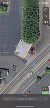
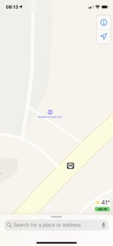
Sigh...some entrance issue that were fixed in old Maps have reverted in the new Maps.

I corrected this Chick Fil A entrance and it was corrected a few months back. When I went there last night, I noticed it was moved back to the main entrance of a nearby mall that it isn’t even in...it is its own separate building in the same general area.

Since entrances is still not back in the new beta, I submitted a fix via the routing edit reporting page to hopefully correct the “arrival” entrance.

bf2b6c22c433dc3026d26d128a125e22.png


006dacdb50200ad7f08d2ad5c20040c8.png


b637f24d5c39c1224eefc255ac42446c.png


29cf976c50cfac5c432672d4e22c238b.png


Edit: I should note though, this seems to be rare. Most of the other POI’s I frequent have really good “arrival” spots at main entrances just off the road instead of the “address” spot.

And at least one can still correct these spots when reporting issues while in routing mode as I posted above.
 
Last edited:
  • Like
Reactions: BBDDVV

gwhizkids

macrumors G5
Jun 21, 2013
13,264
21,422
Used turn-by-turn this morning with the new maps. Did not see the stop light or stop sign icons at intersections. Wondering if that's just going to take some time, or did anyone who lives in other updated areas notice those icons as soon as the new maps went live for your area?

Also, when looking at the Look Around coverage area for the cities that have it already, I have some sneaking suspicion that when it's released for Chicago...my town will probably be juuuuusssst outside the coverage area I'm 50 miles away from the city, but we're still considered the "Chicago Metro area". So maybe we'll luck out and be at the very edge of the initial coverage area
Got them immediately in Connecticut. Still haven’t appeared in Boston, where I am frequently.
 

MozMan68

macrumors 603
Jun 29, 2010
6,152
5,261
South Cackalacky
Got them immediately in Connecticut. Still haven’t appeared in Boston, where I am frequently.

This is the game changer feature. Having used it while in NYC and NJ a few weeks ago, I was totally blown away.

I still have to correct one issue though while I was there. Was heading to a train station in NJ and it told me to turn left at the next stop sign. They updated the intersection since the Apple Car went through and it is now a traffic light. One more thing they have to correct on a regular basis for new roads/intersections.

They'll have to be fast when updating due to a new light or "turn right at the next light" will be worse than the current "make a right on Smith Road."
 
  • Like
Reactions: gwhizkids

G1Ravage

macrumors 65816
Dec 28, 2018
1,096
832
Queens, New York, USA
This is the game changer feature. Having used it while in NYC and NJ a few weeks ago, I was totally blown away.

I still have to correct one issue though while I was there. Was heading to a train station in NJ and it told me to turn left at the next stop sign. They updated the intersection since the Apple Car went through and it is now a traffic light. One more thing they have to correct on a regular basis for new roads/intersections.

They'll have to be fast when updating due to a new light or "turn right at the next light" will be worse than the current "make a right on Smith Road."

Unfortunately, I've encountered numerous such issues. However this likely automated process works, I've seen Apple Maps here show me stop signs in the middle of the street where none exist. Even a large intersection in Manhattan, which has traffic lights of course, was shown as a stop sign on the new maps. I've sent in corrections as I encounter them, but most of these major issues are not presently being addressed.
[automerge]1574342201[/automerge]
Also, a brand new road was just added in my neighborhood (a u-turn lane shortcut beneath the highway). I tried to use the "add a road" function on Apple Maps, but it seems more geared towards adding places than roads. It forces you to add an address! Couldn't really find a way around it.

So I used it, just put the nearby service road name, and then added "entrances" (like for a POI) where the new road begins and ends, and explained myself in the details. So counter-intuitive.
 

MozMan68

macrumors 603
Jun 29, 2010
6,152
5,261
South Cackalacky
Unfortunately, I've encountered numerous such issues. However this likely automated process works, I've seen Apple Maps here show me stop signs in the middle of the street where none exist. Even a large intersection in Manhattan, which has traffic lights of course, was shown as a stop sign on the new maps. I've sent in corrections as I encounter them, but most of these major issues are not presently being addressed.
[automerge]1574342201[/automerge]
Also, a brand new road was just added in my neighborhood (a u-turn lane shortcut beneath the highway). I tried to use the "add a road" function on Apple Maps, but it seems more geared towards adding places than roads. It forces you to add an address! Couldn't really find a way around it.

So I used it, just put the nearby service road name, and then added "entrances" (like for a POI) where the new road begins and ends, and explained myself in the details. So counter-intuitive.

I hope that is what they are addressing with the entrance options. Maybe some other options will be added to make suggestions easier to send.
 

coolsean20

macrumors regular
Apr 23, 2014
235
139
Does anyone have any idea how to report missing buildings in Apple Maps? There’s a couple more places in my city that don’t have the building outlines besides these ones.
[automerge]1574353050[/automerge]
Does anyone have any idea how to report missing buildings in Apple Maps? There’s a couple more places in my city that don’t have the building outlines besides these ones.
Here’s another
[automerge]1574353214[/automerge]
Or how to report unnamed roads?
 

Attachments

  • 6A1E7FB9-EC88-40F5-AD0D-714A2ED5E002.png
    6A1E7FB9-EC88-40F5-AD0D-714A2ED5E002.png
    2.6 MB · Views: 92
  • 51286322-82C4-47CE-B88D-695071A50468.png
    51286322-82C4-47CE-B88D-695071A50468.png
    1.3 MB · Views: 98
  • FA058405-9EFC-4223-B1BD-4E534A5E2B6D.png
    FA058405-9EFC-4223-B1BD-4E534A5E2B6D.png
    1.9 MB · Views: 109
  • C5B835B5-F94C-41FF-A44B-3776C4E328B8.png
    C5B835B5-F94C-41FF-A44B-3776C4E328B8.png
    1.1 MB · Views: 82
  • 05228C93-6C12-4E51-8076-15F358DF0AA0.png
    05228C93-6C12-4E51-8076-15F358DF0AA0.png
    1.1 MB · Views: 113
Last edited:

MozMan68

macrumors 603
Jun 29, 2010
6,152
5,261
South Cackalacky
Does anyone have any idea how to report missing buildings in Apple Maps? There’s a couple more places in my city that don’t have the building outlines besides these ones.
[automerge]1574353050[/automerge]

Here’s another
[automerge]1574353214[/automerge]
Or how to report unnamed roads?


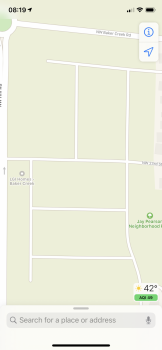
For the buildings, just click on the POI's associated with them and report an issue that way.

For the roads with the missing names, the only thing I could figure out to do was drop a pin on them, route to them (from McMinnville, OR for example) and then click on the "report an issue" there after it is routed to bring up the routing menu. You can click on "other" there to report it and see what happens.

It's weird that they don't let you just drop a pin on the road nd have a "report an issue" button for a pin location. I could swear they did at some point.
 

G1Ravage

macrumors 65816
Dec 28, 2018
1,096
832
Queens, New York, USA
I've been experiencing a strange Siri glitch on Apple CarPlay over the last two days. Anytime CarPlay is reading a text message to me, it concludes each text by reading aloud what appears to be Apple Maps instructions from a previous drive. "Turn slight right onto Cross Island Parkway Frontage Road, and then keep left." It does this every single time, after every text message, reading off the same direction. It's bizarre. And I don't even remember the last time I was even near the Cross Island Parkway.

I just downloaded iOS 13.2.3 this morning, so I guess I'll see if this update fixed that when I go to work this evening.

Switching Siri voices to Male, or to another accent, fixed the problem. But switching back to default Female Siri brought the same problem back.

I was ultimately able to fix the problem for good by turning Siri off in the settings, and then turning it back on.
 

gwhizkids

macrumors G5
Jun 21, 2013
13,264
21,422
Unfortunately, I've encountered numerous such issues. However this likely automated process works, I've seen Apple Maps here show me stop signs in the middle of the street where none exist. Even a large intersection in Manhattan, which has traffic lights of course, was shown as a stop sign on the new maps. I've sent in corrections as I encounter them, but most of these major issues are not presently being addressed.
[automerge]1574342201[/automerge]
Also, a brand new road was just added in my neighborhood (a u-turn lane shortcut beneath the highway). I tried to use the "add a road" function on Apple Maps, but it seems more geared towards adding places than roads. It forces you to add an address! Couldn't really find a way around it.

So I used it, just put the nearby service road name, and then added "entrances" (like for a POI) where the new road begins and ends, and explained myself in the details. So counter-intuitive.

Admittedly, you do live in about the most complicated place in the US for mapping. Just think of the GWB ramp system. Brrr...
 

coolsean20

macrumors regular
Apr 23, 2014
235
139
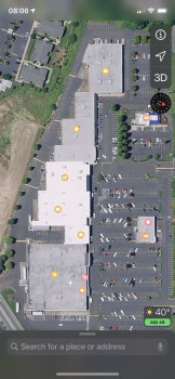
Does anyone know how to report shopping centers to show them as yellow on the map? And are all the shopping centers supposed to be yellow?
 

iOS Geek

macrumors 68000
Nov 7, 2017
1,658
3,443
Does anyone know how to report shopping centers to show them as yellow on the map? And are all the shopping centers supposed to be yellow?
Not quite sure about reporting, to be honest...but I would guess they are supposed to be yellow. All of the ones in my area are, at least...both before the new maps and now after.
[automerge]1574449048[/automerge]
Anyone seeing a new test area? Haven’t seen word of anything anywhere else, and time is ticking! (I still see them hitting their deadline as promised, though. But there definitely isn’t enough time left to have a testing period that has been as long as previous ones)
 

MozMan68

macrumors 603
Jun 29, 2010
6,152
5,261
South Cackalacky
Not quite sure about reporting, to be honest...but I would guess they are supposed to be yellow. All of the ones in my area are, at least...both before the new maps and now after.
[automerge]1574449048[/automerge]
Anyone seeing a new test area? Haven’t seen word of anything anywhere else, and time is ticking! (I still see them hitting their deadline as promised, though. But there definitely isn’t enough time left to have a testing period that has been as long as previous ones)


There are some that are missing. There was a thread on Reddit discussing the shopping centers so I randomly was checking them in the Baltimore area and while most were yellw, there were some that were not. The same thing was true for the grey color associated with cemeteries.
 
  • Like
Reactions: iOS Geek

iOS Geek

macrumors 68000
Nov 7, 2017
1,658
3,443
There are some that are missing. There was a thread on Reddit discussing the shopping centers so I randomly was checking them in the Baltimore area and while most were yellw, there were some that were not. The same thing was true for the grey color associated with cemeteries.
Hmm. I’ll have to look around when I have more time to actually sit and do some serious browsing in the map! Anecdotally (since I’m looking specifically at my town)...with the exception of one park in town, everything is colored. Shopping centers, parks, the cemetery, our college campus, and hospital campus. It’s just one park missing the coloring and because its so small...it would be incredibly easy to miss that detail, especially if they gathered data when it was under construction, since there wouldn’t have been any grass. For a while, there was nothing that would suggest to anyone that that space was going to be a park
 

G1Ravage

macrumors 65816
Dec 28, 2018
1,096
832
Queens, New York, USA
Not sure if this has already been mentioned, but Justin O'Beirne had some interesting bits of information about Apple Maps in his newly combined blog entry about the Midwest/West update.

https://www.justinobeirne.com/new-apple-maps-midwest-west

Fascinating stuff!

That is definitely something. So it seems they're using data gathered from our phones to determine which roads are heavily traveled enough to be considered "artierials", and then the maps (even the new maps) are updating themselves to reflect this data. And when zooming out, less traveled sections of roads vanish first.
 

coolsean20

macrumors regular
Apr 23, 2014
235
139
There are some that are missing. There was a thread on Reddit discussing the shopping centers so I randomly was checking them in the Baltimore area and while most were yellw, there were some that were not. The same thing was true for the grey color associated with cemeteries.
I wanna know how to report them correctly to make them the correct color. Do you know?
 

MozMan68

macrumors 603
Jun 29, 2010
6,152
5,261
South Cackalacky
I wanna know how to report them correctly to make them the correct color. Do you know?

The only way to report is if the shopping center is listed as a separate POI. Sometimes the smaller strip malls, while actually having a name, are not called out on the map like larger malls our outdoor shopping plazas.

Again, if Apple would allow us to report issues with dropped pins, this would be easier, but it’s obvious they are easing into the reporting tools and are only keeping the holdover ones from older Maps for now.

I hope it changes soon.
 

G1Ravage

macrumors 65816
Dec 28, 2018
1,096
832
Queens, New York, USA
Also, a brand new road was just added in my neighborhood (a u-turn lane shortcut beneath the highway). I tried to use the "add a road" function on Apple Maps, but it seems more geared towards adding places than roads. It forces you to add an address! Couldn't really find a way around it.

So I used it, just put the nearby service road name, and then added "entrances" (like for a POI) where the new road begins and ends, and explained myself in the details. So counter-intuitive.

I reported this new road to Apple and Waze. I couldn’t figure out how to report it to Google Maps, so I ignored them.

I already got a message back from a Waze community volunteer confirming my road addition, and they say it’ll be on the Waze map with a day or two.

Let’s see how quickly the Big 3 maps get updated....

C9D1B067-DD29-462C-8BC5-940BA1CA842D.png
 

uhaas

macrumors 6502
Aug 31, 2012
416
203
Boston, MA
Used turn-by-turn this morning with the new maps. Did not see the stop light or stop sign icons at intersections. Wondering if that's just going to take some time, or did anyone who lives in other updated areas notice those icons as soon as the new maps went live for your area?
In the Boston area, the detail has been there for some time, but the traffic lights just came with last Monday’s update, so I’m assuming that each release adds more details, even for one’s that were majorly updated prior.
 
  • Like
Reactions: iOS Geek

uhaas

macrumors 6502
Aug 31, 2012
416
203
Boston, MA
I submitted a POI update for a train station and it’s taking forever to get updated. It’s routing people to the wrong place. Hopefully people aren’t missing their trains.
 
Register on MacRumors! This sidebar will go away, and you'll see fewer ads.