Become a MacRumors Supporter for $50/year with no ads, ability to filter front page stories, and private forums.
Status
The first post of this thread is a WikiPost and can be edited by anyone with the appropiate permissions. Your edits will be public.
Apple sent an email to me this afternoon with a link to enable additional Maps logging on my phone so they can "see" the issue. Then when I submit via feedback, the updated logging tool will give them more info...basically a different profile being added to my phone. I don;t think I've ever been asked for this before??

Anything that gives them the data they need to fix is alright with me I guess.

I've done the same!
 
So....drove the dog over to the high school for his nightly walk (he can run free there) and then remembered to download the profile so I could log my drive home. Profile downloaded, installed and phone re-started.

Drive home was perfectly normal with no delay visible at all...perfect positioning.

Can others do a hard restart and let me know if you experience the same? Wondering if they implemented a fix at the same time as the latest beta (or just a coincidence). A hard restart will force a server side update idf that is what was issued.
 
Map delay is definitely fixed for me… If anything it is a hair quicker than being precise… That is better in my opinion since it gives you time to look down and see the turn…

Not sure if anyone else can confirm, But everything working perfectly for me now.
 
I looked on the Maps of Israel. I haven't seen anything. Maybe only on beta 15.4?
I was about to say that could be the case. I'm on the 15.4 beta and took a look around. I looked near the airport in Tel Aviv and found a station outline. However, I also checked on my Mac, which is not on a beta and saw it as well.

Israel is definitely a country I'm paying attention to for new map updates. I've never been there, but my wife was born and raised, so she'd be able to give me more pointers on where I should be looking to see likely changes/updates.

It's worth noting though that it looks VERY basic. For instance, if I look at a station near me here in the US, I can see the shading/outline of the station with all of the entrances marked. Entrances are marked whether it's an underground station, above ground station that is enclosed, or an above ground station that is just a platform outside with no actual building. The one I found in Israel has the shading/outline but that's it. None of that other information. So it's looking like a start.

EDIT: Found a few more stations. Same story. They have the shading and outline, but no entrance labels. Here's one example:
Screen Shot 2022-02-10 at 3.06.16 PM.png
 
  • Like
Reactions: MozMan68
Map delay is definitely fixed for me… If anything it is a hair quicker than being precise… That is better in my opinion since it gives you time to look down and see the turn…

Not sure if anyone else can confirm, But everything working perfectly for me now.
This has been my experience as well with the latest beta.
 
  • Like
Reactions: Benni14
I was about to say that could be the case. I'm on the 15.4 beta and took a look around. I looked near the airport in Tel Aviv and found a station outline. However, I also checked on my Mac, which is not on a beta and saw it as well.

Israel is definitely a country I'm paying attention to for new map updates. I've never been there, but my wife was born and raised, so she'd be able to give me more pointers on where I should be looking to see likely changes/updates.

It's worth noting though that it looks VERY basic. For instance, if I look at a station near me here in the US, I can see the shading/outline of the station with all of the entrances marked. Entrances are marked whether it's an underground station, above ground station that is enclosed, or an above ground station that is just a platform outside with no actual building. The one I found in Israel has the shading/outline but that's it. None of that other information. So it's looking like a start.

EDIT: Found a few more stations. Same story. They have the shading and outline, but no entrance labels. Here's one example: View attachment 1957158
Israel has not always received a pedestrIan image collection. We can imagine that Apple could achieve this one after New Zealand and Singapore. In any case, the new map data will not arrive immediately for Israel. There are already Japan, Germany, France, New Zealand and Singapore before.
 
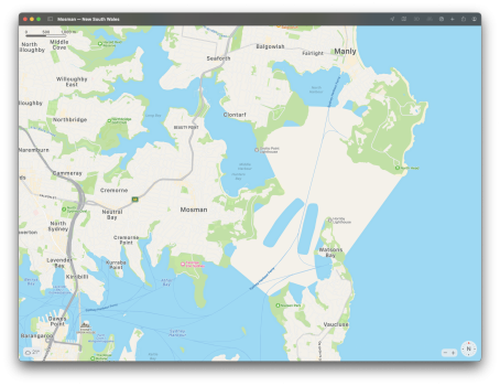
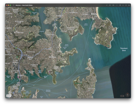
Meanwhile, Apple has turned part of Sydney Harbour into land.
Not limited to iOS 15.4 beta - it seems to be on all versions of iOS 15 and 14 after checking a few devices.

(reported/escalated via email yesterday)
 

Attachments

  • Screen Shot 2022-02-11 at 14.08.16.png
    Screen Shot 2022-02-11 at 14.08.16.png
    2.6 MB · Views: 82
  • Screen Shot 2022-02-11 at 14.08.13.png
    Screen Shot 2022-02-11 at 14.08.13.png
    4.8 MB · Views: 82
Meanwhile, Apple has turned part of Sydney Harbour into land.
Not limited to iOS 15.4 beta - it seems to be on all versions of iOS 15 and 14 after checking a few devices.

(reported/escalated via email yesterday)
I checked on my iPhone and iPad and nothing on my side
 
Speaking of Israel, I just opened Maps to take a look and noticed that you can see POIs for craters on the map, just like mountains. Does anyone know if this is new? Or maybe it’s been there since iOS 15 and I’ve just been looking at the wrong parts of the world on the map to not notice it. Cool nonetheless.
 
Last edited:
Apple has apparently removed the Flyover view from Los Angeles but updated the old 2D satellite imagery. My guess is that this is temporary and that Apple soon will release updated Flyover imagery for the area.
 
  • Like
Reactions: G1Ravage
Drove for the first time today in a week (have been sick). I really didn't notice much change on the Maps lag. Maybe a little better? Still, it doesn't bother me in every day driving.

I'm on the current public release.
 
Drove for the first time today in a week (have been sick). I really didn't notice much change on the Maps lag. Maybe a little better? Still, it doesn't bother me in every day driving.

I'm on the current public release.

Public Beta or standard release?
 
Interesting. The 3D imagery in the satellite view layer…which was recently updated in my area…has been completely removed.

EDIT: Hmm, never mind! Closed the app, went back in…and there it was! Weird…
 
Register on MacRumors! This sidebar will go away, and you'll see fewer ads.