Become a MacRumors Supporter for $50/year with no ads, ability to filter front page stories, and private forums.

mlody

macrumors 68000
Original poster
Nov 11, 2012
1,627
1,240
Windy City
Any improvements to Apple Maps? Is there a way to select transit and walking as driving direction? Currently, there is no way to use transit and walking as it seems Apple Maps will try to push one to take a bus for anything longer than .5 miles distance (could be even less).

Case and point, I live 0.6 miles from Metra station. If I want to create directions to a place in Chicago downtown, the stupid app, will try to put me on a bus to get from home to the Metra station that is 0.6 miles from my home and it screws up the whole direction/timing.
 
  • Like
Reactions: GoldenChild
Maps will automatically mark where you parked your car when you get out and you can see it on the map. It also offers it as a suggested destination when you're in the search bar.
 
  • Like
Reactions: AustinIllini
Does it have the option to avoid toll roads? I've been waiting for this feature for years. Where I live the toll roads are ridiculously expensive for very little time savings, so I avoid them.
 
Still no transit for where i live (Norwich) yet google maps has it, will stick to google maps it seems.
 
I installed DP 1 on an Air 2 and compared it to my Pro. IMHO, the new promised features are interesting. Also, IMHO my main "disappointments" are seeing data from TomTom and the same old mapping data errors - so, right now it's just a new shade of lipstick on an old pig.

Example one: since the iOS 6 Betas Apple Maps erroneously shows traffic incidents at the I-5 and I-205 border between OR and WA, with right now there's an accident reported on the I-5 Bridge but the accident is actually 149 miles north near Des Moines WA; I've had clients avoid the Bridge because they see the Accident icon - after 4 years Apple still hasn't fixed this despite my submitting it as a bug report...

Example two: I've also submitted roadway closures as a civil engineer, including those closed by agencies - and they're still shown as navigable. The Corps of Engineers breached a roadway 3 years ago, and the only way in and out of the area is a lengthy detour. Google fixed it in days, Apple's still.... well, who knows what the hell they're doing...
 
  • Like
Reactions: dk001 and JoEw
Apple Maps might be the most improved app on the first beta.

Except that they removed the only "3D Touch" function I ever used. For some reason they took away the ability to 3D Touch the map icon and get directions home.
 
What about the line markers? What I like about google navigation is that it will show at top line markers for turns etc. Apple just simple says turn left or right omitting essential details as what lines turn what direction etc.
 
Anyone having issue w 6s plus navigation not working. It just sticks in same location and arrow doesn't move. Either car or walking.

I'm on a 6S and have the same issue. Navigation is totally borked for me. Same sticks in one location deal.

Fortunately Google Maps still works perfectly..
 
They added ride-sharing functionality too. It doesn't work yet (says no apps are available in the store). It'll be nice if you can book uber/lyft directly or at least pre-populate from maps. I haven't navigated with the new maps yet but I already used maps pretty frequently in Phoenix, D.C., Florida and Connecticut and really don't have issues with it.

Someone mentioned the parked car thing. I'm looking at it now and it seems accurate. I didn't have to use maps for that to happen either.
 
The location icon to move the map to your current location now has 3 states. One tap shifts the map to your location. A second tap toggles the mode that rotates the map in real-time to your orientation. These both existed on all previous versions. However, a third tap now turns the icon hollow but, at least on my phone, doesn't seem to do anything else. Has anyone figured out what this mode means?
 
Does the live traffic UI in Apple Maps look like Google Maps now or is it still showing "Brick traffic UI"?
 
I'm on a 6S and have the same issue. Navigation is totally borked for me. Same sticks in one location deal.

Fortunately Google Maps still works perfectly..

Figured this out. You have to turn on every location service including the product improvement ones. Tried a few combos of Turing some off but could not find the right pattern. The only ones I have off are location iads and HomeKit. Turn those on and restart the app. Should work.
 
The location icon to move the map to your current location now has 3 states. One tap shifts the map to your location. A second tap toggles the mode that rotates the map in real-time to your orientation. These both existed on all previous versions. However, a third tap now turns the icon hollow but, at least on my phone, doesn't seem to do anything else. Has anyone figured out what this mode means?
It just cancels out of tracking your compass direction and location (if you were moving), much like simply tapping and dragging elsewhere.

Hollow arrow is the default state
 
Any improvements to Apple Maps? Is there a way to select transit and walking as driving direction? Currently, there is no way to use transit and walking as it seems Apple Maps will try to push one to take a bus for anything longer than .5 miles distance (could be even less).

Maybe Transit, Citymapper or Moovit could also be good options for you. It depends where you live and use it.

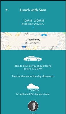
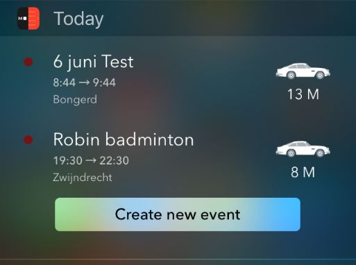
Maybe you could also look at other alternatives like the calendar widget/app from Moleskine Timepage. See also my post regarding calendar apps with indication of traveltime to your (next) appointment with car/bike/walking. I'm afraid they don't support public transport like Google Maps does but maybe you can suggest the developers to add it.

The widget of Moleskine Timepage shows all travel times (in minutes/hours) for both car/bike/walking in the Notification Center widget 'Today' so maybe you can use it aside from Google Maps.

EjOHmmU.png
FHZbKbJ.png
 
Last edited:
Any improvements to Apple Maps? Is there a way to select transit and walking as driving direction? Currently, there is no way to use transit and walking as it seems Apple Maps will try to push one to take a bus for anything longer than .5 miles distance (could be even less).

Case and point, I live 0.6 miles from Metra station. If I want to create directions to a place in Chicago downtown, the stupid app, will try to put me on a bus to get from home to the Metra station that is 0.6 miles from my home and it screws up the whole direction/timing.
I noticed no one ever answered your question, the answer is yes, you can un-check buses.

IMG_2027.PNG


Here is a route to Wrigley Field with buses, which completely bypasses Metra.

IMG_2030.PNG


Here is the same route to Wrigley without buses.

IMG_2029.PNG
 
Last edited:
Register on MacRumors! This sidebar will go away, and you'll see fewer ads.