Become a MacRumors Supporter for $50/year with no ads, ability to filter front page stories, and private forums.
When I pull down the Today view in iOS 9, I get told how long to drive to a location I frequent at that time on that particular day. It's a nice touch.

My friend can't drive due to disabilities and relies on public transport only, is it possible to have the Maps widget in iOS 10 give public transport predictions to his frequent locations rather than driving times?

I know this can be done in the Google Search app if the app is given permission for location tracking , Google Now has the option to show public transport only. However a built in iOS feature would be preferred!
File the report/request with Apple!
 
  • Like
Reactions: Lion007s
When I pull down the Today view in iOS 9, I get told how long to drive to a location I frequent at that time on that particular day. It's a nice touch.

My friend can't drive due to disabilities and relies on public transport only, is it possible to have the Maps widget in iOS 10 give public transport predictions to his frequent locations rather than driving times?

I know this can be done in the Google Search app if the app is given permission for location tracking , Google Now has the option to show public transport only. However a built in iOS feature would be preferred!

Apple Maps doesn't have Transit yet in my city, but have you taken any look at the new Maps Transit widget in iOS 10? It might do what you're asking. (Can't test because like I said, no Transit enabled for Apple Maps in my city yet)
 
  • Like
Reactions: Lion007s
File the report/request with Apple!

Already requested! :)

Apple Maps doesn't have Transit yet in my city, but have you taken any look at the new Maps Transit widget in iOS 10? It might do what you're asking. (Can't test because like I said, no Transit enabled for Apple Maps in my city yet)

I don't have iOS 10 installed on my device (6S Plus) since it's my daily driver, was hoping if anyone else could shed some light on if this is possible or not
 
When I pull down the Today view in iOS 9, I get told how long to drive to a location I frequent at that time on that particular day. It's a nice touch.

My friend can't drive due to disabilities and relies on public transport only, is it possible to have the Maps widget in iOS 10 give public transport predictions to his frequent locations rather than driving times?

I know this can be done in the Google Search app if the app is given permission for location tracking , Google Now has the option to show public transport only. However a built in iOS feature would be preferred!
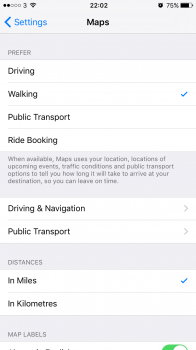
I haven't seen/used this feature but the text under the preferences here suggests it maybe applies to frequent locations
 

Attachments

  • IMG_3518.PNG
    IMG_3518.PNG
    86.8 KB · Views: 242
  • Like
Reactions: Lion007s
For people who drive, new features include next destination ETA and Parked location. I personally really like the "Parked car" feature, it automatically knows where was last time you left your car and later on just a tap away, it guides you back to your car.

dashboard.png
 
Apple maps working very well for me. It's just eating too much battery right now though, more than 1% per minute. Even turning the screen off (but let it run in the background and rely on the audio cues) doesn't help too much.
 
So I know iSO 10 includes 'automatic' rerouting for Apple Maps if there is traffic, but I just got a audible pop-up on my girlfriend's iPhone telling me that I can save 10 minutes by selecting this new route. This particular iPhone is running 9.3.2.

IMG_0273.PNG
 
So I know iSO 10 includes 'automatic' rerouting for Apple Maps if there is traffic, but I just got a audible pop-up on my girlfriend's iPhone telling me that I can save 10 minutes by selecting this new route. This particular iPhone is running 9.3.2.

View attachment 637102

I saw that feature in iOS 9

Weird. I have never had it pop-up for me over the last year. Not in 9.3.3 either.

Makes you wonder if there is some back end magic going on here, too.
 
Maps will automatically mark where you parked your car when you get out and you can see it on the map. It also offers it as a suggested destination when you're in the search bar.

I know that the parking widget thing is linked up to the Bluetooth but can anyone tell me if it works when you have just like a Bluetooth speaker phone in your car because your car is too old to actually pair to anything? LOL Will it drop the pin when you Turn your Bluetooth speakerphone off or does it only work with newer cars that you can actually pair your phone to?
 
For those asking about transit, yes, if your city has transit data it will use that if you set your preferred mode of transportation to transit in settings. It's been excellent for this New Yorker.
 
  • Like
Reactions: Lion007s
I really like the new maps but on my device the battery drain for maps is high. I will connect my phone to the USB port in the car and its not enough to keep my 6S Plus battery charged. It will slow the drain but a full charge will only last about 2 hours of navigation. I have to use one of the power connections from a lighter adapter to keep the phone alive. Maybe it was this way before but I don't think as bad. No complaints, just saying I see a high battery use at the moment.
 
  • Like
Reactions: rdinterman
Figured this out. You have to turn on every location service including the product improvement ones. Tried a few combos of Turing some off but could not find the right pattern. The only ones I have off are location iads and HomeKit. Turn those on and restart the app. Should work.

This worked for me! Thanks! Kinda weird because previous iOS versions worked fine.
 
Assuming that the pink transit station outlines appearing in a city are an indicator that transit directions are close to being ready for that city, then places that could be added in the near future are:

Japan looks nearly complete, the routes lines are there and some already show local branding.

Dallas
Houston
San Diego
Vancouver
Manchester
Newcastle/Sunderland
Glasgow
Prague
More Amtrak
More UK National Rail

This is all just guessing, so I'm curious to see if this works as a predictor.
 
Last edited:
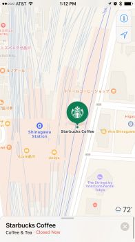
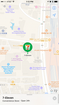
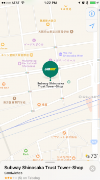
In Japan, some POI markers are using specific branding rather than the generic Apple symbols, has anyone seen this anywhere else?
 

Attachments

  • IMG_2038.PNG
    IMG_2038.PNG
    480.9 KB · Views: 241
  • IMG_2037.PNG
    IMG_2037.PNG
    441.2 KB · Views: 240
  • IMG_2043.PNG
    IMG_2043.PNG
    315.9 KB · Views: 239
  • Like
Reactions: kerk09
In Japan, some POI markers are using specific branding rather than the generic Apple symbols, has anyone seen this anywhere else?
I'm not sure I have yet but it appears they might be highlighting businesses that take ApplePay?
 
Interesting thought, but Apple Pay hasn't launched in Japan, which is the only place they seem to appear.
You're right. I look at the same map locations and see the icons as well. I looked closer to home and don't find any brands but do see the icons on the list view match the map view so as they are updated I assume we will see more of them. Good find.
 
Register on MacRumors! This sidebar will go away, and you'll see fewer ads.