What are you including in your feedback? I've found that attaching a screenshot of satellite view as well as one of the standard view with a drawing of what I'm talking about has given me more luck. However, for a lot of them, I've had to go to Google to get the satellite imagery since their imagery is more recent.Meh...I've asked them three times to create a building model which has been missing for my local White Castle, and they've yet to do so. 😕
Got a tip for us?
Let us know
Become a MacRumors Supporter for $50/year with no ads, ability to filter front page stories, and private forums.
The iOS14 Apple Maps Thread
- Thread starter MozMan68
- WikiPost WikiPost
- Start date
- Sort by reaction score
You are using an out of date browser. It may not display this or other websites correctly.
You should upgrade or use an alternative browser.
You should upgrade or use an alternative browser.
- Status
- The first post of this thread is a WikiPost and can be edited by anyone with the appropiate permissions. Your edits will be public.
What are you including in your feedback? I've found that attaching a screenshot of satellite view as well as one of the standard view with a drawing of what I'm talking about has given me more luck. However, for a lot of them, I've had to go to Google to get the satellite imagery since their imagery is more recent.
I've tried both methods. Most recently, as someone else had done here or on Reddit, I included a map screenshot, and drew in a line showing the boundaries of the building.

improvemaps
macrumors regular
Have you assigned the corresponding relationship to the contacts in question in the Contacts app?Why is Apple Maps still not linked properly to Contacts? When I search for "Dad" it gives me these bizarre results, same for "Mum"... is there a setting I am missing?
View attachment 1660601
Last edited:
improvemaps
macrumors regular
I don't think this solution will work for @timeislove (who I believe is located in Hong Kong). The Refine Location feature is only supported in select cities in the United States at the moment.I usually see this indoors. It means Apple Maps doesn't have as precise an idea of where you are as normal. If you're outside and see this, you can use your phone's camera to "scan" the buildings around you, and then Apple Maps will know precisely where you are.
timeislove
macrumors 6502a
I usually see this indoors. It means Apple Maps doesn't have as precise an idea of where you are as normal. If you're outside and see this, you can use your phone's camera to "scan" the buildings around you, and then Apple Maps will know precisely where you are.
would I be prompted for “scanning” the surrounding? I noted a similar features had been available for google map for quite a while.
by the way, I upgraded iOS to 14.2. Isn’t there a new feature in Map to submit comments and photos of places? Why I did not see it on Map?
timeislove
macrumors 6502a
I found landmark places working on Map app but not on Contact app. It looks like Map heavily relying on the mapping of POI to street addr, which is not in place with Contact app.Have you assigned the corresponding relationship to the contacts in question in the Contacts app?
Don’t know if the relationship form part of POI mapping.
Last edited:
would I be prompted for “scanning” the surrounding? I noted a similar features had been available for google map for quite a while.
by the way, I upgraded iOS to 14.2. Isn’t there a new feature in Map to submit comments and photos of places? Why I did not see it on Map?
If you touch on your "blue" cone vision on the map, it'll give you the option to scan your surroundings.
The feature to submit comments and photos hasn't appeared for me yet, either.
timeislove
macrumors 6502a
What are you including in your feedback? I've found that attaching a screenshot of satellite view as well as one of the standard view with a drawing of what I'm talking about has given me more luck. However, for a lot of them, I've had to go to Google to get the satellite imagery since their imagery is more recent.
any ways to suggest a better or sensible route to Apple?
I found they were quick to fix street addr info (reply after the weekend) , however, for the route I submitted to them over 2 month, I have yet received any response.
The estate I am living is about 3 min walk from train station. For any destination I searched the routes from home, Map app suggested to walk 10 min to nearby bus stop to take bus to the next next train station.
However, Map knows a 10 min walking path (not the usual path I walk) if I search the direct route from home to the nearby train station.
strange!
I’m guessing you are selecting “transit” directions from your house, so it is just giving you the closest way to start that type of direction.
If you only want to take the train, you need to “walk” to the train station and then select transit directions from there.
But...you could also route it the way you are now and then “report an issue” to suggest the walk to the train station route as a preferred/better way.
timeislove
macrumors 6502a
I’m guessing you are selecting “transit” directions from your house, so it is just giving you the closest way to start that type of direction.
If you only want to take the train, you need to “walk” to the train station and then select transit directions from there.
But...you could also route it the way you are now and then “report an issue” to suggest the walk to the train station route as a preferred/better way.
tks for your reply. I could not follow with you.
I selected the icon looks like a train, I suppose it is about “public transportation “, same as how it is implemented in google map.
let me rephrase the issue.
Map app suggested a 9 min walking path from my place to the nearby train station (actually I could walk another path within 3-5 min)
what make me felt strange was, when I searched the route from my place to other destinations, Map would suggest to walk 10 min to a bus stop then take bus (apparently there would be wait time) to the next next train station (just checked now it suggested to take bus to next train station) then take train to the destination.
obviously, walking to the nearby train station make much sense in terms of counting the nos of transit or the sum of time taken.
if Map knows there is a nearby train station, why it seems to skip this station in the calculation of routing?
any idea?
Last edited:
There are two ways to report issues within the app.tks for your reply. I could not follow with you.
I selected the icon looks like a train, I suppose it is about “public transportation “, same as how it is implemented in google map.
let me rephrase the issue.
Map app suggested a 9 min walking path from my place to the nearby train station (actually I could walk another path within 3-5 min)
what make me felt strange was, when I searched the route from my place to other destinations, Map would suggest to walk 10 min to a bus stop then take bus (apparently there would be wait time) to the next next train station (just checked now it suggested to take bus to next train station) then take train to the destination.
obviously, walking to the nearby train station make much sense in terms of counting the nos of transit or the sum of time taken.
if Map knows there is a nearby train station, why it seems to skip this station in the calculation of routing?
any idea?
1) For POI information, simply select the POI on the map and select "report an issue" or drop a pin on the map to report a missing location/POI
2) For routing issues like you are experiencing or if you would like to submit a route correction or improvement, start a route as you are doing and THEN select "report an issue." This will allow you to suggest the route to the closer train station.
If you can share your general location (not your house, but maybe a nearby POI that will provide the same routing??) and the route you are taking so we can replicate, some of us on here have been successful determining WHY Apple Maps is doing this or in many cases, confirming that there is indeed an issue and we can also suggest corrections.
Or if you prefer to send a direct message, I'd be happy to look at the route on my phone and see what is going on. 🙂
improvemaps
macrumors regular
Is the preferred walking path that you mentioned mapped or is it missing from the map entirely? If it's missing, I'd suggest that you report the missing path as a separate problem. You can then try directions again (once it's been added) and see if it suggests the new path. If not, then you can report a problem about a better route like @MozMan68 suggested.tks for your reply. I could not follow with you.
I selected the icon looks like a train, I suppose it is about “public transportation “, same as how it is implemented in google map.
let me rephrase the issue.
Map app suggested a 9 min walking path from my place to the nearby train station (actually I could walk another path within 3-5 min)
what make me felt strange was, when I searched the route from my place to other destinations, Map would suggest to walk 10 min to a bus stop then take bus (apparently there would be wait time) to the next next train station (just checked now it suggested to take bus to next train station) then take train to the destination.
obviously, walking to the nearby train station make much sense in terms of counting the nos of transit or the sum of time taken.
if Map knows there is a nearby train station, why it seems to skip this station in the calculation of routing?
any idea?
I think he stated in an earlier post that it will map him to the closer station if he just picks that station as a destination point...I think....Is the preferred walking path that you mentioned mapped or is it missing from the map entirely? If it's missing, I'd suggest that you report the missing path as a separate problem. You can then try directions again (once it's been added) and see if it suggests the new path. If not, then you can report a problem about a better route like @MozMan68 suggested.
timeislove
macrumors 6502a
Is the preferred walking path that you mentioned mapped or is it missing from the map entirely? If it's missing, I'd suggest that you report the missing path as a separate problem. You can then try directions again (once it's been added) and see if it suggests the new path. If not, then you can report a problem about a better route like @MozMan68 suggested.
oh, maybe I made you guys confused.
Map knows a walking path to a nearby station (9min) though not my preferred one.
regardless, Map direct me to walk to a nearby bus stop (10 min) then take a bus to next next train station.
what look weird are:
Map skip the nearby train station even it knows there is a walking path which is shorter than walking to bus stop.
Map direct me to transit more (walk to bus to train) and take much more time (overall) even there is a direct train to the destination (another train station)
any idea?
timeislove
macrumors 6502a
There are two ways to report issues within the app.
1) For POI information, simply select the POI on the map and select "report an issue" or drop a pin on the map to report a missing location/POI
2) For routing issues like you are experiencing or if you would like to submit a route correction or improvement, start a route as you are doing and THEN select "report an issue." This will allow you to suggest the route to the closer train station.
If you can share your general location (not your house, but maybe a nearby POI that will provide the same routing??) and the route you are taking so we can replicate, some of us on here have been successful determining WHY Apple Maps is doing this or in many cases, confirming that there is indeed an issue and we can also suggest corrections.
Or if you prefer to send a direct message, I'd be happy to look at the route on my phone and see what is going on. 🙂
actually I posted a pic showing the issues.
Pls Refer to the thread below (#565).
The iOS14 Apple Maps Thread
Any reason why Map app is able to show a walking route to a nearby Train station, but searching for the route from the location to other train station, Map would suggest to walk to bus stop to take bus to the next train station and take train to the destination station? It seems like the nearby...
 forums.macrumors.com
Sorry...I assumed you were in the new Maps area (UK).actually I posted a pic showing the issues.
Pls Refer to the thread below (#565).
The iOS14 Apple Maps Thread
Any reason why Map app is able to show a walking route to a nearby Train station, but searching for the route from the location to other train station, Map would suggest to walk to bus stop to take bus to the next train station and take train to the destination station? It seems like the nearby...
My answer really doesn't change though. You can make the suggestions I noted, but I wouldn't expect much to change until Apple owned Maps is integrated as well as the local transit directions.
DingeZ
macrumors member
I've looked at it and it seems there is a small stretch of road just in front of station that is marked as not allowed for pedestrians, which results in that if you try to plan a transit-trip it cannot find a walking route to the station entrance. Whereas if you try a pedestrian trip just to the station, the directions just end at the closest pedestrian-routable place near the station.oh, maybe I made you guys confused.
Map knows a walking path to a nearby station (9min) though not my preferred one.
regardless, Map direct me to walk to a nearby bus stop (10 min) then take a bus to next next train station.
what look weird are:
Map skip the nearby train station even it knows there is a walking path which is shorter than walking to bus stop.
Map direct me to transit more (walk to bus to train) and take much more time (overall) even there is a direct train to the destination (another train station)
any idea?
timeislove
macrumors 6502a
I still didn’t understand what you call “local transit direction”
do you mean Map does not depends on the routing distance to determine the possible transit but rely on local provide to tell them there is a transit path (incl. walking path)?
do you mean Map does not depends on the routing distance to determine the possible transit but rely on local provide to tell them there is a transit path (incl. walking path)?
Sorry...I assumed you were in the new Maps area (UK).
My answer really doesn't change though. You can make the suggestions I noted, but I wouldn't expect much to change until Apple owned Maps is integrated as well as the local transit directions.
timeislove
macrumors 6502a
I've looked at it and it seems there is a small stretch of road just in front of station that is marked as not allowed for pedestrians, which results in that if you try to plan a transit-trip it cannot find a walking route to the station entrance. Whereas if you try a pedestrian trip just to the station, the directions just end at the closest pedestrian-routable place near the station.
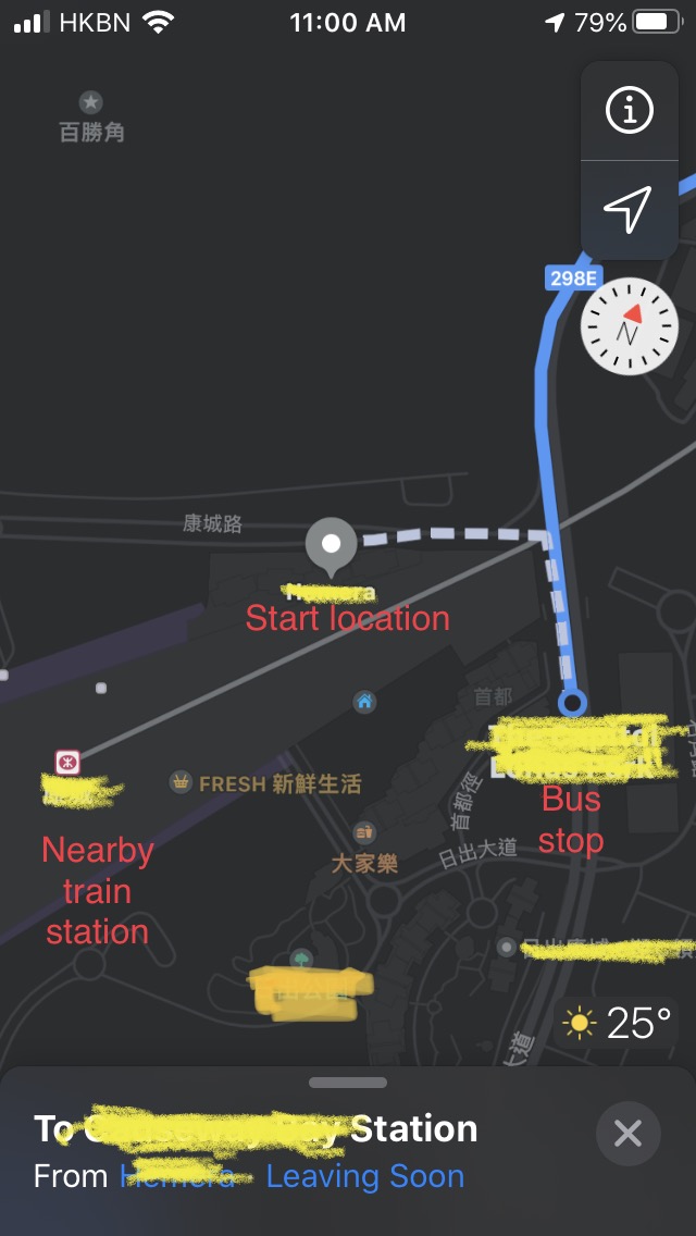
attached the searched route to the nearby station, it indicates 7 minutes walking.
do you mean when search for “walking” route, Map would give the path walking to the closest point but *not* guarantee to reach the destination? (That s really surprised me) Hence not warrant a possible transit in the calculation of routing?
I guess you are talking about the gap I marked in a red arrow in the pic.
so, what should I do?
it affects searches route for all destinations from my estates.
I did submit the preferred 3 min walk path to the nearby train station about two month ago, but still did not hear any response from apple.
Attachments

Last edited:
When you hit "report an issue" while in routing mode as you are in the picture, does it give you an option to edit "entrances" for the train station?attached the searched route to the nearby station, it indicates 7 minutes walking.
do you mean when search for “walking” route, Map would give the path walking to the closest point but *not* guarantee to reach the destination? (That s really surprised me) Hence not warrant a possible transit in the calculation of routing?
I guess you are talking about the gap I marked in a red arrow in the pic.
so, what should I do?
it affects searches route for all destinations from my estates.
I did submit the preferred 3 min walk path to the nearby train station about two month ago, but still did not hear any response from apple.
That is one of the biggest advancements from old to new Maps. The ability to add various entrances based on the mode of transport. In your picture, that would be a typical end point if driving and then it should tell you to walk to the station, but only if there is an option for a walking entrance noted.
My guess is that the map is not complete or updated to that level in Hong Kong yet.
timeislove
macrumors 6502a
When you hit "report an issue" while in routing mode as you are in the picture, does it give you an option to edit "entrances" for the train station?
That is one of the biggest advancements from old to new Maps. The ability to add various entrances based on the mode of transport. In your picture, that would be a typical end point if driving and then it should tell you to walk to the station, but only if there is an option for a walking entrance noted.
My guess is that the map is not complete or updated to that level in Hong Kong yet.
hmmm ... so, what you are telling me is Map indicates to walk to an end point closest to the station, but not warrant a transit cos there was no entrance marked for the station?!
attached the “adding arrival entrance” page (now available after upgraded from iOS 13.4 to 14.2) What should I do?
could I just copy a screenshot of what google map shows ? Good enough for Apple to add the required entrance?
Attachments

dk001
macrumors demi-god
Just upgraded to 14.3 b2 and as usual dropped into Maps...
The local view has reverted to something old. I had originally reported this back in 13.x and it was fixed.
If you look in the satellite view, you see a thin park with a foot/bike path and the housing property lines/fences.
In the Map view it makes the path the property lines.
Map matched satellite. Sometime recently it looks to have reverted.
timeislove
macrumors 6502a
When you hit "report an issue" while in routing mode as you are in the picture, does it give you an option to edit "entrances" for the train station?
That is one of the biggest advancements from old to new Maps. The ability to add various entrances based on the mode of transport. In your picture, that would be a typical end point if driving and then it should tell you to walk to the station, but only if there is an option for a walking entrance noted.
My guess is that the map is not complete or updated to that level in Hong Kong yet.
tks for your reply.
i posted a reply to you about the adding arrival entrance.
however, I later found the station entrance was actually there, it only appears when I search for a route of public transport. If i search for a walking path to the station, the map would not show the entrance (that was the photo I posted previously)
attached another photo showing the entrance A and the end point of the walking path to station (search for public transportation route from my estates)
still dunno why Map skip the nearby train station to search route for any other destination.
Attachments

timeislove
macrumors 6502a
Just upgraded to 14.3 b2 and as usual dropped into Maps...
The local view has reverted to something old. I had originally reported this back in 13.x and it was fixed.
If you look in the satellite view, you see a thin park with a foot/bike path and the housing property lines/fences.
In the Map view it makes the path the property lines.
Map matched satellite. Sometime recently it looks to have reverted.
View attachment 1672885View attachment 1672887View attachment 1672886
should the map view depend on the web data and not iOS dependent?
should the map view depend on the web data and not iOS dependent?
They sometimes use beta periods as an opportunity to make changes or test Map features like when the new Naps area was introduced for the first time.
It was done then because you HAD to have the new iOS to access new Maps.
Not sure why it would matter now.