Become a MacRumors Supporter for $50/year with no ads, ability to filter front page stories, and private forums.
Status
The first post of this thread is a WikiPost and can be edited by anyone with the appropiate permissions. Your edits will be public.
As the other post says the two aren’t linked.

There will be an update splash

That’s not entirely true. In the past, particularly when Maps was “new”, it was released only to those on the beta to limit exposure in case things didn’t work.

That only changed in the USA to being pre-released to a select portion of users before a general release AFTER it was proven that the releases were working without major issues.

While in general one could say Apple has done this before, we are now talking about whole new countries with different driving rules, signage, etc. It makes sense that Apple will release new Maps to those on the beta only as they did with Northern California so they can get a couple of months of feedback/usage before a release to the general public in the Fall.
 
Just thinking out loud here. They talked way back about bringing the new maps to the whole world. When we look at the pace Maps has taken so far and what we’re expecting to see this year...I really am wondering how long that’ll take. So far, the wait has been worth it, so I have no problem with the wait itself. I’m just curious as to when it’ll be finished. In the back of my head, I have this feeling that Apple might eventually start going crazy and power through, putting releases out one after the other! When would that be? Who knows.
 
Just thinking out loud here. They talked way back about bringing the new maps to the whole world. When we look at the pace Maps has taken so far and what we’re expecting to see this year...I really am wondering how long that’ll take. So far, the wait has been worth it, so I have no problem with the wait itself. I’m just curious as to when it’ll be finished. In the back of my head, I have this feeling that Apple might eventually start going crazy and power through, putting releases out one after the other! When would that be? Who knows.

I agree...they've done the hard part; working through the bugs around actually releasing the new Maps. Now they can focus on collection of data and individual country politics, rules, etc. The level of complexity in the USA alone from state to state shows that it can be done and done well. It really is impressive looking at Maps now compared to what else is out there. Can't wait to see other countries!
 
  • Like
Reactions: iOS Geek
I agree...they've done the hard part; working through the bugs around actually releasing the new Maps. Now they can focus on collection of data and individual country politics, rules, etc. The level of complexity in the USA alone from state to state shows that it can be done and done well. It really is impressive looking at Maps now compared to what else is out there. Can't wait to see other countries!
Exactly. The US was a great way to work out any kinks. It had the obvious advantage of being Apple's home country, but you're right about complexity...we've got everything here. From dense, cities that have tight grid systems, to cities that are pretty complex in other ways, to tiny pinpoint towns with a whole lot of nothing in between. As you remember, I was bummed about the Alaska release coming AFTER I got home from my winter trip. My summer trip was cancelled (thanks COVID!), so while I can't yet use the maps while I'm there...I've still been browsing through them. (I'm hoping we can still go this winter, but I'm not holding my breath on that one. The situation will determine that one of course)! Of all the states...Alaska impressed me most with the new maps. I imagine it was probably the toughest area to do but they NAILED IT! What I look forward to most with Alaska though is Look Around. I wonder what the coverage for that will be, given that so many towns are off the road network. But Google Maps has Street View in Nome, for example. So it CAN be done. I imagine it's just a case of getting the person and the equipment up there, get a car in whatever given town and go from there.
 
Exactly. The US was a great way to work out any kinks. It had the obvious advantage of being Apple's home country, but you're right about complexity...we've got everything here. From dense, cities that have tight grid systems, to cities that are pretty complex in other ways, to tiny pinpoint towns with a whole lot of nothing in between. As you remember, I was bummed about the Alaska release coming AFTER I got home from my winter trip. My summer trip was cancelled (thanks COVID!), so while I can't yet use the maps while I'm there...I've still been browsing through them. (I'm hoping we can still go this winter, but I'm not holding my breath on that one. The situation will determine that one of course)! Of all the states...Alaska impressed me most with the new maps. I imagine it was probably the toughest area to do but they NAILED IT! What I look forward to most with Alaska though is Look Around. I wonder what the coverage for that will be, given that so many towns are off the road network. But Google Maps has Street View in Nome, for example. So it CAN be done. I imagine it's just a case of getting the person and the equipment up there, get a car in whatever given town and go from there.


They already have the data for Look Around as it was built into every mapping vehicle.

The "Look Around" specific cars or even Street View cars that people see out and about are probably the same as well and are just advertised that way to show that they are collecting updated imagery versus street routing data.

Releasing Look Around is really no different than street data, but damn, so much to check via AI as well as then double checked by human eyes. I'm predicting that after the 10 major cities are released in the USA, you will see a mass release of Look Around for the rest of the country all at once or at a minimum in large regional swaths.
 
  • Like
Reactions: iOS Geek
They already have the data for Look Around as it was built into every mapping vehicle.

The "Look Around" specific cars or even Street View cars that people see out and about are probably the same as well and are just advertised that way to show that they are collecting updated imagery versus street routing data.

Releasing Look Around is really no different than street data, but damn, so much to check via AI as well as then double checked by human eyes. I'm predicting that after the 10 major cities are released in the USA, you will see a mass release of Look Around for the rest of the country all at once or at a minimum in large regional swaths.
I could see that being how it goes. Get those 10 cities done and out of the way and everything else is much easier. Just like how the US was released in regions and once they got the complex ones out of the way, they released the rest in one huge chunk, which actually surprised me a little. They could have easily broken that release up into maybe 2 or 3 more sections.
 
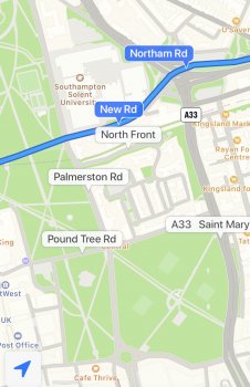
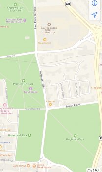
So I am still on iOS 13 and was driving around Southampton via CarPlay earlier this week and the map looked new to me....entirely different to how it has been over recent times. Every patch of grass was green, even small sections adjacent to roads and footpaths shown in larger green areas in locations where they had not been shown before. These changes don’t appear on the iOS maps app, only in CarPlay.

I will take some comparison photos when I can and post here for peoples thoughts.

Hmmm...do me a favor. Even from your phone itself while you're home, set a destination to activate navigation instructions, and see if that extra "greenery" comes back while in navigation mode.
 
Hey, look what’s in here! I remember seeing this a few months back, but the hours were listed exactly the same for both sections. Nice to see these temporary hours actually reflecting what they are instead of showing the normal hours as they previously did.
C54C5D4C-DA80-42F1-939C-C8D1ADDE97B0.jpeg
 
  • Like
Reactions: MozMan68
For those on iOS 14 beta already, if you're setting a destination through CarPlay, does Maps show you the mileage (distance) to your destination when selecting one of the available routes? I'm talking about on the screen where you're selecting a possible route.

I'm still kinda mad that this information doesn't show on CarPlay on iOS 13. Seems so basic....
I'll have to look closely next time I get in the car. I can't recall if I saw it or not last time.
 
Quick question that I haven’t seen addressed here or elsewhere yet: here in NYC I get a “Directions are not available between these locations” when I try to do cycling directions. I can get it to give cycling directions in SF no problem. Would someone be able to check whether they work in NYC for them so I can stop trying if it’s just not there yet? :p
 
Quick question that I haven’t seen addressed here or elsewhere yet: here in NYC I get a “Directions are not available between these locations” when I try to do cycling directions. I can get it to give cycling directions in SF no problem. Would someone be able to check whether they work in NYC for them so I can stop trying if it’s just not there yet? :p
Apple put out a pretty short list of locations that will have cycling directions right off the bat. NYC wasn’t one of them, and unfortunately for me...neither was the Chicago area 😂
 
Apple put out a pretty short list of locations that will have cycling directions right off the bat. NYC wasn’t one of them, and unfortunately for me...neither was the Chicago area 😂

NYC definitely was one of them, it should be NYC, SF, LA and a bunch of places in China.

edit: just double checked LA, and I’m not getting directions there either, so I guess they’ve only flipped the switch for SF so far
 
Apple put out a pretty short list of locations that will have cycling directions right off the bat. NYC wasn’t one of them, and unfortunately for me...neither was the Chicago area 😂
NYC was definitely one of the initial locations getting cycling directions. I’ve been checking every day 😁and still not live yet. I feel like on day one the cycling directions option wasn’t there (am I imagining that?). Now the icon is there.
 
I added the cities mentioned when this thread was started...it’s on the front page and will be updated.

May start a separate section just for the cycling feature update there.
 
  • Like
Reactions: Alhagar
NYC was definitely one of the initial locations getting cycling directions. I’ve been checking every day 😁and still not live yet. I feel like on day one the cycling directions option wasn’t there (am I imagining that?). Now the icon is there.
Oops, my bad, you're right! Ha, it's even the first one on their list! 🤦‍♂️ I blame exhaustion!
 
  • Like
Reactions: Alhagar
Hmmm...do me a favor. Even from your phone itself while you're home, set a destination to activate navigation instructions, and see if that extra "greenery" comes back while in navigation mode.

As per the below. Roughly the same area. First one is during navigation and the second isn’t.

You are right it appears in navigation mode. Anyone have any thoughts if this is a soft roll out?
 

Attachments

  • E4BE7A43-3C5B-4F1A-80DD-8A262628EE72.jpeg
    E4BE7A43-3C5B-4F1A-80DD-8A262628EE72.jpeg
    729.7 KB · Views: 166
  • 2DEAE1FF-2624-4DB5-8FDF-0FEFE15B7BE4.jpeg
    2DEAE1FF-2624-4DB5-8FDF-0FEFE15B7BE4.jpeg
    506.6 KB · Views: 170
  • Like
Reactions: xodh and G1Ravage
As per the below. Roughly the same area. First one is during navigation and the second isn’t.

You are right it appears in navigation mode. Anyone have any thoughts if this is a soft roll out?
That happened at nearly every pre-launch just before it went live.

Back in the iOS 12 days, even before the first of the "new maps" sections of California ever went live, the "navigation mode" mode in Apple Maps had certain extra details that didn't appear when looking at the regular map. Most major cities in America had these added details which were only available in navigation mode. While not the fully detailed new maps themselves, there was added greenery where applicable, and a few extra details in the parks, although not to the same level of detail as the new maps proper. Outside of the major cities, there was a lot more green also, but it appeared to be randomly and haphazardly applied.

I am not certain if these "extra" navigation mode details were already present in major European cities like they were in America before the new maps rolled out. If you believe you just started seeing this detail recently, then it's likely Apple has activated some sort of temporary layer of new detail as some sort of test. Can't say for sure if that means a larger rollout is nearby or not.

If you were to zoom out a bit, you'll see that even in navigation mode, this "extra" detail vanishes once you pass a certain level of zoom-out. If you zoom out as far as you can without losing the extra detail, you may also see that this extra detail is limited only to the "center regions" of the major cities. Let me know if that's true for you as well. Does the extra detail disappear once you're nearing the edges of the city?

For New York City, before we had the new maps roll out, the "extra" detail in navigation mode was limited to a certain-mile radius around Manhattan. It covered all of Manhattan, a tiny sliver of eastern New Jersey near the Hudson River, as well as most of central and western Bronx, western Queens, and northwestern Brooklyn.
 
  • Like
Reactions: MozMan68
Back in the iOS 12 days, even before the first of the "new maps" sections of California ever went live, the "navigation mode" mode in Apple Maps had certain extra details that didn't appear when looking at the regular map. Most major cities in America had these added details which were only available in navigation mode. While not the fully detailed new maps themselves, there was added greenery where applicable, and a few extra details in the parks, although not to the same level of detail as the new maps proper. Outside of the major cities, there was a lot more green also, but it appeared to be randomly and haphazardly applied.

I am not certain if these "extra" navigation mode details were already present in major European cities like they were in America before the new maps rolled out. If you believe you just started seeing this detail recently, then it's likely Apple has activated some sort of temporary layer of new detail as some sort of test. Can't say for sure if that means a larger rollout is nearby or not.

I drive in the area quite a bit and it could have only happened recently.

If you were to zoom out a bit, you'll see that even in navigation mode, this "extra" detail vanishes once you pass a certain level of zoom-out. If you zoom out as far as you can without losing the extra detail, you may also see that this extra detail is limited only to the "center regions" of the major cities. Let me know if that's true for you as well. Does the extra detail disappear once you're nearing the edges of the city?

Yes the layer disappears when zooming out in navigation mode. Seems it’s localised to larger metro areas. extends quite far out and then stops. Just tried London and it worked the same.

For New York City, before we had the new maps roll out, the "extra" detail in navigation mode was limited to a certain-mile radius around Manhattan. It covered all of Manhattan, a tiny sliver of eastern New Jersey near the Hudson River, as well as most of central and western Bronx, western Queens, and northwestern Brooklyn.
I shall evaluate more when I‘m next driving in the area.
 
That’s exactly what I see when I’m driving in Prague, Czech Republic on some places around the city center for about a year now (only in driving mode). But it seems not to tight to the new Apple Maps, since no AM cars are surveying our country yet
 
Here is an example of an issue I am seeing in iOS13 and iOS14 for walking directions. I suspect there is an issue with Apple Maps when going from “driving” to a “walking” directions.
Put in directions from my place to a nearby Chiropractic.
A14A52B5-8062-4858-80D8-1276ED6B2643.jpeg1ED37438-DA48-4079-B58E-62526BFE964D.jpeg
In Apple Maps, the directions take you to the parking lot but not to the actual location. It appears to follow the driving directions and just replaces these with “steps”.
Take a look at the corresponding trip in Google Maps.
14A93157-C832-4691-8514-12DB4EC11340.jpeg88986BF4-352F-4244-8CD3-2366C3BA2F8C.jpeg
It actually plots the walking path and takes you right to the location.
 
Here is an example of an issue I am seeing in iOS13 and iOS14 for walking directions. I suspect there is an issue with Apple Maps when going from “driving” to a “walking” directions.
Put in directions from my place to a nearby Chiropractic.
View attachment 928726View attachment 928728
In Apple Maps, the directions take you to the parking lot but not to the actual location. It appears to follow the driving directions and just replaces these with “steps”.
Take a look at the corresponding trip in Google Maps.
View attachment 928727View attachment 928733
It actually plots the walking path and takes you right to the location.

That's part of the reason they added multiple entrances to the early betas last year...and then pulled them.

It had separate entrances for walking, driving, etc. Hoping they bring that back as an option for us to recommend versus waiting for the Apple team to figure it out (which they will never be able to do without local input).
 
  • Like
Reactions: dk001 and Shifts
I’d like to ask some opinions on a possible Feedback report I might send in to Apple. Dark Mode for Maps. Do you think it’s too difficult to differentiate anything? I’m thinking of making a suggestion to maybe make the colors a little more “obvious”. It’s not an actual issue for me, but I think there could be a benefit for some people to make those colors pop more in Dark Mode.

Any opinions of yours could be added to my feedback report, hence why I’m asking. Basically what I’m thinking is do you think Dark Mode is a little TOO dark on Maps?
 
  • Like
Reactions: dk001 and Alhagar
Register on MacRumors! This sidebar will go away, and you'll see fewer ads.