Got a tip for us?
Let us know
Become a MacRumors Supporter for $50/year with no ads, ability to filter front page stories, and private forums.
All Devices Updated Apple Maps
- Thread starter Aussi3
- WikiPost WikiPost
- Start date
- Sort by reaction score
You are using an out of date browser. It may not display this or other websites correctly.
You should upgrade or use an alternative browser.
You should upgrade or use an alternative browser.
- Status
- The first post of this thread is a WikiPost and can be edited by anyone with the appropiate permissions. Your edits will be public.
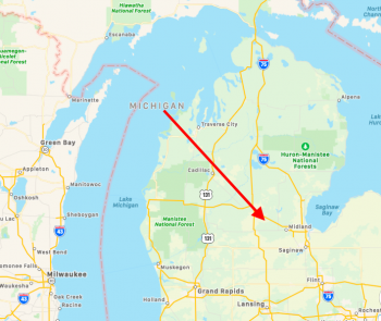
I'm well aware that it has an upper peninsula, thank you very much. But the "middle of the state"...is not over Lake Michigan. 🤷♂️ The arrow I've drawn...is roughly the area where it used to be. It is not currently located where it has been for pretty much...forever. So it's worth reporting 🤷♂️Dude.... The state of Michigan has an upper peninsula. The label is right in the "middle of the state", like it is for every other state.
Attachments
I have a completed US!!! Only on my iPad though.
I finally have the complete US, but only on one Mac. Not showing yet on other Mac, iPad, either iPhone, or even the other MacOS partition on the Mac that has it working.I have a completed US!!! Only on my iPad though.
I'm well aware that it has an upper peninsula, thank you very much. But the "middle of the state"...is not over Lake Michigan.The arrow I've drawn...is roughly the area where it used to be. It is not currently located where it has been for pretty much...forever. So it's worth reporting

I see what you’re talking about...it’s “centered” across what is actually the entire state (taking the U.P. Into account), but the position doesn’t make much sense for the casual observer.
Proper position is over the main body of the state (the mitten).

[automerge]1578681610[/automerge]I see what you’re talking about...it’s “centered” across what is actually the entire state (taking the U.P. Into account), but the position doesn’t make much sense for the casual observer.
Proper position is over the main body of the state (the mitten).I almost wonder if there was some sort of “data clash” between what was “new” and what was “old”, because ever since getting the new maps for the rest of the US...it’s now back over the “mitten“. Or maybe it was just a weird bug. But on my other devices that don’t have the new maps...it’s still over the lake. So you’ll be seeing it like that until the rest of the maps come out.
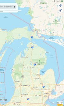
No idea how I screwed that last post up 😂 But I’ve got a screenshot there for you. It will fix itself when the new maps come out. It shows correctly over the “mitten” on my iPad. But on devices that don’t have the new maps...it still shows up over the Lake.I see what you’re talking about...it’s “centered” across what is actually the entire state (taking the U.P. Into account), but the position doesn’t make much sense for the casual observer.
Proper position is over the main body of the state (the mitten).

Attachments
[automerge]1578681610[/automerge]
No idea how I screwed that last post upBut I’ve got a screenshot there for you. It will fix itself when the new maps come out. It shows correctly over the “mitten” on my iPad. But on devices that don’t have the new maps...it still shows up over the Lake.
Wow...so updated with the “new” update that doesn’t affect that area. Interesting.
Makes me feel even better that they are grouping updates for new Maps areas that are tied to the unreleased area. Makes sense to issue changes grouped together like that.
Still gone from all devices. Showed up on wife iPhone 11 for half a day; gone again
Typically means the release is imminent...typically.
Maybe Monday!
But I’m still thinking the 20th.
Yep. Although, (and probably because it was the only "issue" I was actively looking to see fixed and wasn't paying attention to anything anywhere else), that was the only change I saw take place in a previously released area. It'll be interesting to see how often updates are done to places once the initial rollout is complete. (From changes due to road construction, new buildings, etc). There's a major construction project going on on a primary road in my area. This all started after Apple drove through here, and it's a three year project, so I wonder how long after the project is done it will take for Apple to reflect it. The way the road was like when they came through...is nothing like what it will be when it's done. The current data...is still good for during the work, but once it's done, the current data will be VERY inaccurate. Since there will be a lot of places where turns will no longer be allowed from a specific direction, entrances that will no longer exist, and entrances that will exist then but don't now...it will be a change that has to be reflected quickly otherwise it'll cause some problems.Wow...so updated with the “new” update that doesn’t affect that area. Interesting.
Makes me feel even better that they are grouping updates for new Maps areas that are tied to the unreleased area. Makes sense to issue changes grouped together like that.
Yep. Although, (and probably because it was the only "issue" I was actively looking to see fixed and wasn't paying attention to anything anywhere else), that was the only change I saw take place in a previously released area. It'll be interesting to see how often updates are done to places once the initial rollout is complete. (From changes due to road construction, new buildings, etc). There's a major construction project going on on a primary road in my area. This all started after Apple drove through here, and it's a three year project, so I wonder how long after the project is done it will take for Apple to reflect it. The way the road was like when they came through...is nothing like what it will be when it's done. The current data...is still good for during the work, but once it's done, the current data will be VERY inaccurate. Since there will be a lot of places where turns will no longer be allowed from a specific direction, entrances that will no longer exist, and entrances that will exist then but don't now...it will be a change that has to be reflected quickly otherwise it'll cause some problems.
The same situation is going on near me...a major redesign of a highway interchange (new bridges and everything). It is almost complete.
I did give an example earlier though of a road change that they implemented with the new Maps data that happened after the car drove through, so it has happened.
It would appear that certain city-funded programs must have a direct line with Apple for super-quick map updates.
Citi Bike is a bike-sharing program in New York City. Citi Bike docking stations are shown on Apple Maps. There's one on the corner where I work.
I drove to work one day a few months ago, and noticed that the Citi Bike POI icon on that corner had disappeared. I then discovered that the Citi Bike docking station had been removed, and relocated two blocks away. The reason for the relocation was so the street could be torn up for repaving. The new docking location was properly shown on Apple Maps.
Yesterday, I arrived at work and noticed that the Citi Bike icon on my corner had returned. Sure enough, the bike dock was back in its original location. Must've happened overnight, and somehow the icon was already correct.
This is driving me nuts. I set up and new iCloud account and saved locations won't sync to the iCloud. Even if I have iCloud Drive and Maps enabled in the iCloud menu. Tried several things like logging in and out of iCloud, rebooting, uninstall and reinstall Maps app (which deleted all my saved location because they weren't synced), and disabling all ads blocking. I wonder if it have anything to do with the fact that it's a new account. Also the saved locations are newly created while logged into the new account.
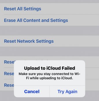
Edit: Tapping on Ease All Content and Settings to force iCloud to complete syncing, it said Upload to iCloud Failed, and on the other phone the upload is stuck on 93%. Am I paranoid or sometimes iCloud is simply down? (the phone have internet connection)
Edit: I signed the phones back to the old iCloud account and the sync works right away.
Attachments
Last edited:
Anyone know if there's a way to import saved locations from Google Maps to Apple Maps? I have hundreds of saved locations in Google Maps and would love to have them in Apple Maps too.
Anyone know if there's a way to import saved locations from Google Maps to Apple Maps? I have hundreds of saved locations in Google Maps and would love to have them in Apple Maps too.
Nope...can’t be done.
Nope...can’t be done.
That's frustrating. If Apple wants people to move to Apple Maps, they should make it easy to make the transition.
I don't particularly want to stop using Google Maps but I'd love to be able to use one or the other easily and have all my data. Google Maps already lets you export all your locations as a JSON file; the work is half done! C'mon, Apple.
Had a nice little surprise with more "natural" directions today while working in Chicago.
I rarely use walking directions, but I did this time simply since I hadn't been to Chicago since the update, so used them for the mile or so walk from the train station to my office. Coming up to my office, I have to cross the Chicago River and instead of saying "in 900 feet, turn left onto N. Orleans Street" it said, "make the next left and cross the bridge." Didn't even mention the street until I actually had to cross that to get to my building.
Not a big deal when walking since I have enough time to see or even look for street signs, but as some of you may know, that's almost impossible in a lot of cities. This natural style of giving directions as well as the addition of the stop sign/traffic light integration is such a huge deal and game changer, I'll be surprised if Apple doesn't do a bigger announcement on it sometime the first half of this year as the USA is rolled out in more detail.
It’s getting Really frustrating that some devices are getting the new maps and others are stuck on the old. It’s been over a month that it’s updated on my phone but none of my other devices.
It’s getting Really frustrating that some devices are getting the new maps and others are stuck on the old. It’s been over a month that it’s updated on my phone but none of my other devices.
Considering I live in one of the Update #7 areas, and neither my three iOS devices or my Mac has it, I have difficulty feeling bad for you about the above.
Any guesses on what the next area will be released for Look Around? Unless I’m wrong, it seemed like at least one city came with each released region. Surprised to see Chicago still doesn’t have it.
Maybe we’ll see some rapid rollout of it once expansion #7 goes live...
Maybe we’ll see some rapid rollout of it once expansion #7 goes live...
Any guesses on what the next area will be released for Look Around? Unless I’m wrong, it seemed like at least one city came with each released region. Surprised to see Chicago still doesn’t have it.
Maybe we’ll see some rapid rollout of it once expansion #7 goes live...
I doubt it will be rapid...maybe a little quicker.
Boston, Philly, Chicago, Seattle would be my next guesses....or actually, Dallas first.
I think the plan for hitting major cities first and then expanding out makes sense (and yes, should be much quicker with residential areas).
Have new maps on my new iPad. Dropped old one, used Apple Care to get a new one and new Maps came along for the ride!
Haven't seen the new maps yet, myself.
Me either...but I think I called Monday the 20th weeks ago for wide release and I’ll stick with that. Seems like a lot going on as far as people getting it and losing it, which is always a good sign.
Register on MacRumors! This sidebar will go away, and you'll see fewer ads.


 The arrow I've drawn...is roughly the area where it used to be. It is not currently located where it has been for pretty much...forever. So it's worth reporting
 But I’ve got a screenshot there for you. It will fix itself when the new maps come out. It shows correctly over the “mitten” on my iPad. But on devices that don’t have the new maps...it still shows up over the Lake.
